

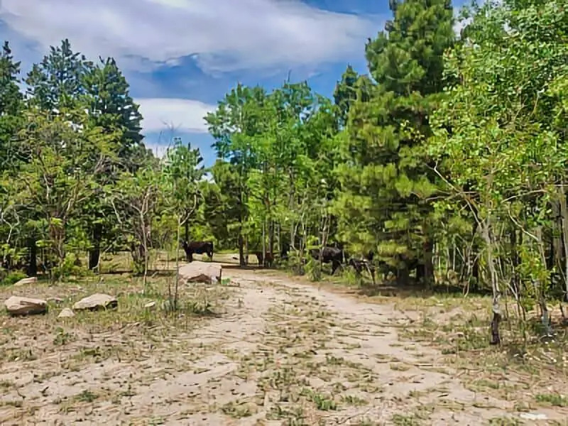
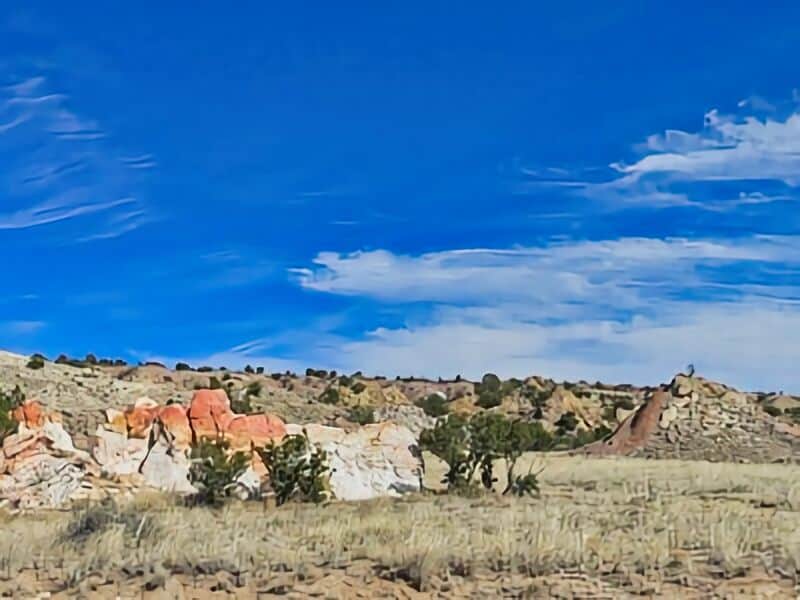
Paliza Goblin Colony Free Boondocking Locations: The Paliza Goblin Colony offers some of the best boondocking locations for those looking to camp in a unique, natural setting.
We can find several spots near the colony’s rock formations and along Valecito Creek, where dispersed camping is allowed, providing a quiet experience away from crowds.
These sites give us easy access to hiking trails and amazing views without the need for developed campsites.
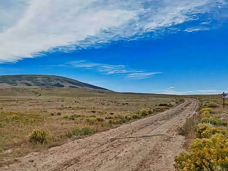
Getting to the area is straightforward; we can reach the colony via Forest Road 10 near Ponderosa, New Mexico. The road is gravel but usually passable for most vehicles, making it convenient for campers looking to stay close to the rock formations.
This spot is perfect for those who enjoy exploration and want a peaceful place to rest under the stars.
While the hike to the colony is moderately challenging, boondocking nearby lets us experience the landscape without extra effort. We get to enjoy the eerie beauty of the “goblins” up close while having a base camp that doesn’t limit our freedom or connection to nature.
Location and Access
The Paliza Goblin Colony is located near Paliza Canyon in New Mexico.
To reach the area, we start by driving north on Forest Road 271 from Paliza Canyon. The colony lies about half a mile past the entrance to the Paliza Family area.
The trail to the Goblin Colony is roughly 3 miles long and goes out and back. It usually takes around 1 hour and 15 minutes to hike. This route is moderately challenging, so we should be prepared for some uneven terrain.
For those interested in boondocking, the area offers options nearby but does not have developed facilities. We should come ready for primitive camping and bring all necessary supplies including water, food, and shelter.
Key access points:
- Start at Paliza Canyon entrance
- Drive north on Forest Road 271
- Follow signs past Paliza Family area
The trail is clearly marked, but cell service may be limited. We recommend bringing a map or GPS navigation to help stay on course.
Camping spots are mostly dispersed. It’s best to choose a site away from the main trail to minimize impact and enjoy privacy during our stay.
Directions to Paliza Goblin Colony Free Boondocking Locations: How To Get There And What To Expect
To reach the Paliza Goblin Colony, we start near Jemez Pueblo, New Mexico.
From Bernalillo, we take US 550 north to San Ysidro. Then, we turn right onto State Route 4 toward Jemez Pueblo.
After passing Jemez Pueblo, we take a right onto Forest Road 271. This road takes us north, about half a mile past the entrance to the Paliza Family area. The Goblin Colony lies nearby, and the drive is on a dirt road that may require a high-clearance vehicle.
Alternatively, we can hike in by following Valecito Creek. The trail approaches the goblins from below and offers a closer, quieter way to explore.
When we arrive, we should expect a rugged, natural area. There are no formal campsites, so boondocking means camping without hookups or services. We must bring all supplies and pack out our trash.
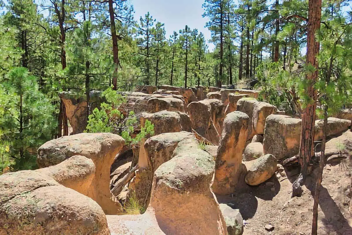
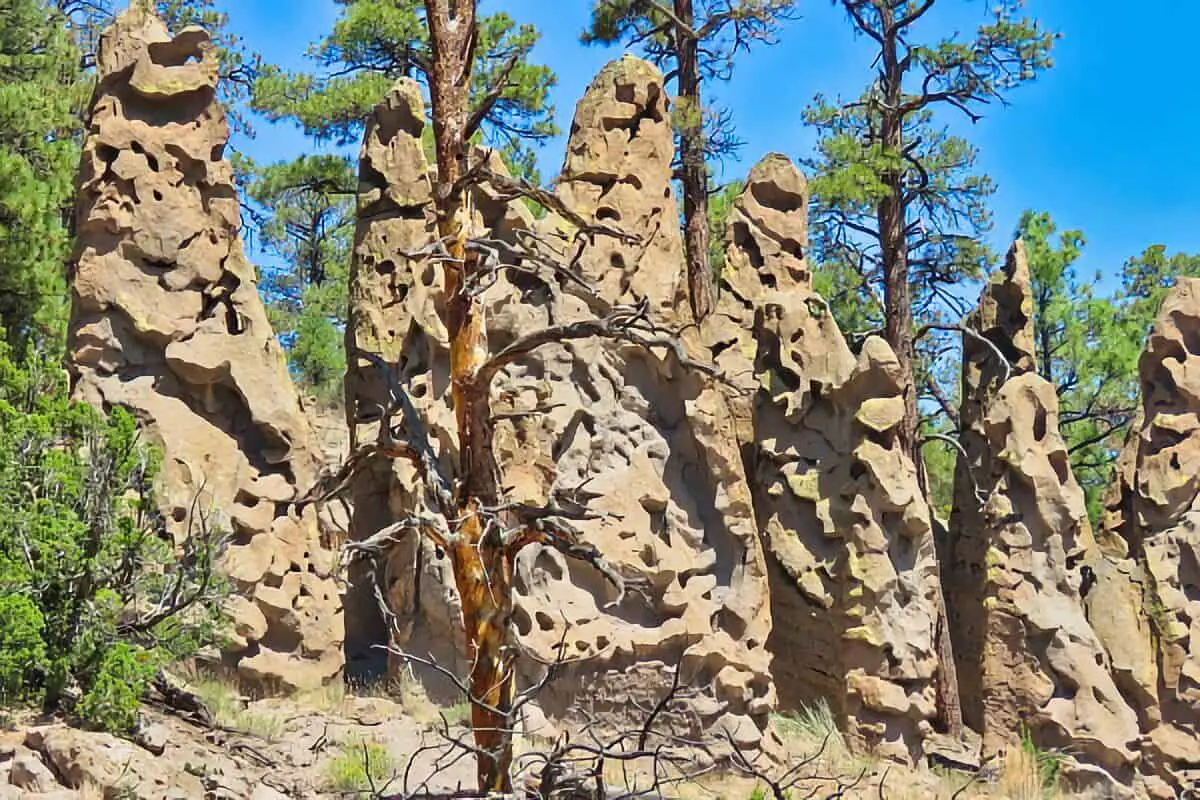
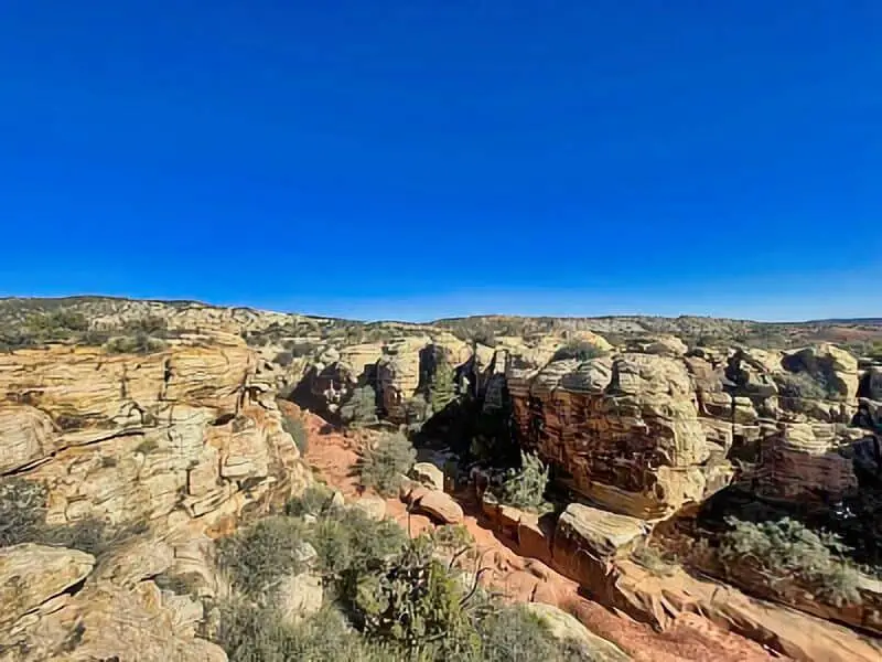
The landscape features unique rock formations called goblins, shaped by erosion. These areas appear remote and quiet, perfect for those who want solitude.
Tips for the trip:
- Use a reliable GPS or map.
- Bring enough water and food.
- Prepare for uneven, rocky terrain.
- Anticipate limited cell service.
- Respect the natural environment and local regulations.
Amenities And Activities
The Paliza Goblin Colony area has very limited amenities. There are no developed facilities like restrooms, water hookups, or trash collection.
Boondocking here means camping without traditional campground services. We rely on our own gear and prepare for a more rugged experience. The site is best suited for self-sufficient adventurers comfortable with primitive conditions.
For activities, hiking is the main option. We can explore unique rock formations known as goblins, which are stone pillars shaped by erosion. The nearby forest road offers scenic views but requires a high-clearance vehicle.
Photography and nature observation are popular. We can enjoy quiet time, watch wildlife, and take in the natural landscape without crowds.
| Amenities | Notes |
|---|---|
| Water | Bring your own |
| Restrooms | None on site |
| Trash Disposal | Pack out all trash |
| Cell Phone | Limited or no service |
| Parking | Primitive, dirt road access |
| Activities | Description |
|---|---|
| Hiking | Explore goblin rock formations |
| Photography | Capture unique landscapes |
| Wildlife Viewing | Spot local animals |
We recommend checking road and weather conditions before visiting. The area is remote and can be challenging to access.
Camping Regulations And Restrictions At the Paliza Goblin Colony Free Boondocking Locations
When camping at the Paliza Goblin Colony, we must follow specific rules to protect the natural area. This location is managed by the USDA Forest Service, which sets guidelines to keep the land clean and safe.
Boondocking here means camping without hookups or designated sites. We need to camp at least 100 feet away from water sources to reduce impact. Fires may be limited or banned during dry seasons, so checking fire restrictions before going is important.
We should pack out all trash and leave no trace. This helps preserve the area for other visitors and wildlife. Pets must be kept on a leash, and we need to respect quiet hours, usually from 10 p.m. to 6 a.m.
Camping stays may be limited to 14 days in a 30-day period. If we plan to camp longer, we must check with the local ranger station for permits or rules.
Here is a quick overview of key rules:
| Regulation | Details |
|---|---|
| Distance from water | At least 100 feet |
| Fire restrictions | Seasonal, check before camping |
| Trash | Pack out all trash |
| Pets | Leash required |
| Quiet hours | 10 p.m. to 6 a.m. |
| Maximum stay | 14 days in 30-day period |
Leave No Trace
When we visit the Paliza Goblin Colony for boondocking, it is important to respect the natural environment. We must carry out everything we bring in to keep the area clean and natural for others.
We should avoid damaging plants or disturbing rocks and wildlife. Goblin formations are fragile, so we must stay on marked paths and campsites.
Trash should go in sealed bags and packed out with us. If we see litter left behind, we can help by picking it up.
Campfires should be small and only used in designated fire rings when allowed. We must fully put out fires before leaving and never leave them unattended.
We also want to minimize noise to keep the area peaceful for everyone. Respecting quiet hours helps both wildlife and other visitors.
Here are some key Leave No Trace principles to follow at Paliza Goblin Colony:
| Principle | Action Tip |
|---|---|
| Plan Ahead | Know rules and camp in allowed spots |
| Travel & Camp on Durable Surfaces | Use established campsites and trails |
| Dispose of Waste Properly | Pack out what you bring in |
| Leave What You Find | Don’t move or take rocks or plants |
| Minimize Campfire Impact | Use small fires or alternatives |
| Respect Wildlife | Observe quietly from a distance |
| Be Considerate of Others | Keep noise down and share space |
By following these simple steps, we help protect the beauty and health of the Paliza Goblin Colony for future visits.
Information Resources
Santa Fe National Forest – Paliza Goblin Colony Information
Bandelier National Monument
New Mexico Hiking Guide – Paliza Goblin Colony Trails
Paliza Goblin Colony Free Boondocking Locations
Mesa de Cuba
36.023074, -107.01115
Mesa de Cuba sits west of the town of Cuba, offering dispersed camping along dirt roads on BLM land. The area is surrounded by red rock formations and open mesas. This site is primitive and remote, with no facilities or services.
Things to Do:
Explore nearby rock formations, hike across the mesa, or use the site as a base for ATV riding. Stargazing is excellent due to minimal light pollution.
Directions:
From Cuba, take US-550 south, then head west on Mesa de Cuba Road. Continue to the coordinates for scattered pull-off spots.
Vehicle Access:
Access roads are dirt and may become slick after rain. High-clearance vehicles are recommended. Not ideal for large RVs due to rough conditions.
Cuba Forest Road 88
36.0711, -107.0096
Forest Road 88 offers dispersed camping in the Santa Fe National Forest northeast of Cuba. The road cuts through pine forest and open meadow areas, providing scenic pullouts for dry camping.
Things to Do:
Popular for hiking, mountain biking, and nature watching. Nearby forest trails are accessible, and it’s a good spot for quiet, short-term stays.
Directions:
From Cuba, take NM-126 east, then turn north on FR 88. Campsites can be found along the road after a few miles.
Vehicle Access:
FR 88 is gravel and typically passable for most vehicles, but a high-clearance vehicle is advisable, especially in wet conditions.

Resumidero Camping Area
36.111742, -106.748667
Resumidero is a developed forest service camping area northwest of Coyote. While still remote, it offers vault toilets and a few designated sites. It’s surrounded by mixed conifer forest and has access to hiking and fishing.
Things to Do:
Hiking, horseback riding, and ATV use on nearby trails. Trout fishing is available in seasonal streams.
Directions:
From Coyote, head north on FR 93, then west on FR 103 to Resumidero. The camping area is clearly marked and maintained during the warmer months.
Vehicle Access:
Gravel roads require a high-clearance vehicle. Suitable for truck campers and small RVs.

Coyote Canyon
36.072, -106.6302
Coyote Canyon provides dispersed camping options south of the town of Coyote. It’s a quiet area with some shaded spots and access to primitive roads through the forest.
Things to Do:
Best suited for hiking and quiet nature camping. Local wildlife is active, and the area connects with nearby trail networks.
Directions:
From Coyote, travel southeast toward the coordinates using local forest roads branching off FR 93. Look for pullouts or cleared areas suitable for camping.
Vehicle Access:
Roads are narrow and unpaved. High-clearance vehicles are required. Not suitable for large rigs.

Canada de Guardia
36.063889, -106.662341
Cañada de Guardia offers remote, dispersed camping within the Santa Fe National Forest. The site features a rugged landscape of canyons and forested slopes, with limited traffic and peaceful surroundings.
Things to Do:
Hiking, wildlife observation, and exploring off-road trails. Ideal for campers seeking solitude and natural beauty.
Directions:
From Coyote, head southeast on Forest Road 93, then take side roads toward the provided coordinates. Campsites are primitive and unmarked.
Vehicle Access:
Rough forest roads require high-clearance 4WD vehicles. Not recommended for RVs or low-clearance setups.
Boondocking Jemez Springs Hot Rock
35.87619, -106.69321
Located near the town of Jemez Springs, this boondocking spot is set along a dirt forest road with scenic views and geothermal activity nearby. It’s a dry camping area with no services.
Things to Do:
Soak in nearby natural hot springs, hike surrounding trails, or visit nearby geological sites like Soda Dam.
Directions:
From Jemez Springs, head west on Highway 4, then turn onto FR 376 and follow it to the coordinates. Look for level pullouts along the route.
Vehicle Access:
FR 376 can be rough and muddy in wet weather. A high-clearance vehicle is strongly recommended.
San Diego Canyon Overlook
35.8547, -106.6249
This overlook site provides elevated views of San Diego Canyon and surrounding mesas. It’s a remote, dry camping spot without amenities.
Things to Do:
Photography, birdwatching, or use as a quiet base for day hikes in the Jemez Mountains.
Directions:
From Jemez Springs, follow Highway 4 north to FR 10. Continue west toward the overlook, following GPS to the location.
Vehicle Access:
Unpaved roads may be rough in sections. High-clearance vehicles recommended. Not suited for long trailers.
Jemez Pueblo Gilman Tunnels
35.72994, -106.75855
This boondocking location lies near the dramatic Gilman Tunnels—old railroad tunnels carved into rock cliffs. The area offers primitive sites along forest roads.
Things to Do:
Visit the historic tunnels, explore scenic rock formations, and hike surrounding areas. The site is quiet and shaded by trees.
Directions:
From Jemez Pueblo, head north on NM-485. Follow the road through the tunnels to find boondocking spots near the coordinates.
Vehicle Access:
Paved to the tunnels, but gravel roads beyond can be rough. High-clearance or AWD recommended beyond the main road.
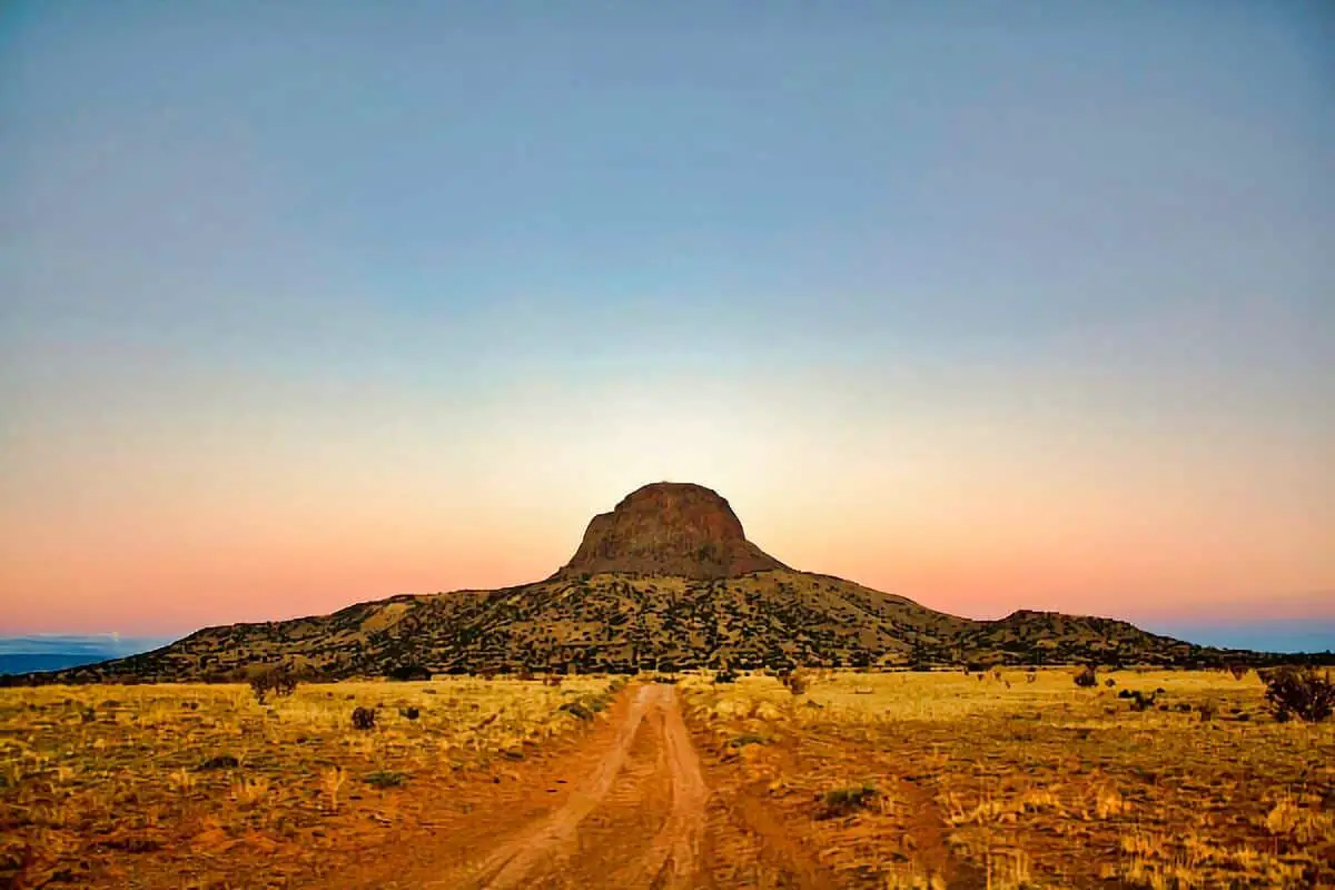
Cabezon Peak
35.610124, -107.12188
Situated near the iconic volcanic neck of Cabezon Peak, this remote boondocking site offers sweeping views and rugged terrain. There are no services, and the camping is primitive.
Things to Do:
Hike to Cabezon Peak’s base, photograph dramatic landscapes, and stargaze with minimal light pollution.
Directions:
From San Luis, follow County Road 279 north. Turn onto Cabezon Road and continue toward the peak. Campsites are near the base, along side pullouts.
Vehicle Access:
Dirt roads become rough and impassable when wet. High-clearance 4WD is advised, especially beyond Cabezon Road junctions.
Cabezon Road
35.50252, -106.813744
Cabezon Road provides dispersed camping along an unpaved route toward Cabezon Peak. The area is isolated, quiet, and has scenic desert surroundings.
Things to Do:
Explore abandoned homesteads, drive off-road trails, and hike toward geologic features in the area.
Directions:
From San Ysidro, travel north on US-550 and turn west onto Cabezon Road (CR 906). Continue to the provided coordinates for open, flat spots.
Vehicle Access:
Dirt road is generally passable in dry conditions but can become rutted. High-clearance vehicles recommended.
San Ysidro
35.568383, -106.81285
This boondocking area is close to the town of San Ysidro and offers convenient access to nearby trails, badlands, and open desert. It’s a dry camp spot with no amenities.
Things to Do:
Mountain biking, ATV riding, and hiking. Nearby Ojito Wilderness provides more exploration options.
Directions:
From San Ysidro, follow Forest Road 906 or 279 west to find level boondocking pullouts off the main track.
Vehicle Access:
Generally accessible in dry conditions. AWD or high-clearance suggested beyond the first few miles.
Paliza Goblin Colony Paid Campgrounds

Fenton Lake
35.881891, -106.731132
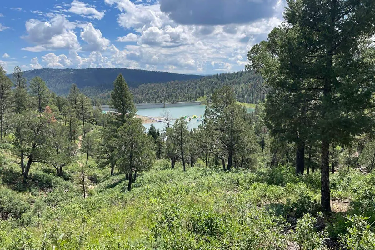
Fenton Lake State Park sits at an elevation of around 7,900 feet in the Jemez Mountains and offers limited boondocking options just outside the developed campground. The lake itself is a 37-acre cold-water lake, making it a popular destination for anglers looking to catch rainbow trout and occasionally stocked browns. While the main park includes developed camping areas with vault toilets and water hydrants, dispersed camping is possible in the surrounding Santa Fe National Forest with more primitive conditions.
Things to Do: Fishing is the primary draw at Fenton Lake, with non-motorized boating also allowed. Trails nearby offer light to moderate hiking, and wildlife viewing is common. The surrounding forest includes access to scenic drives and day-use areas, including battleship rock and the nearby Valles Caldera.
Directions: From Jemez Springs, travel north on NM-4 to NM-126, then head west. The road to Fenton Lake is paved until you approach the lake; dirt roads leading to dispersed areas are nearby but less maintained.
Vehicle Access: Paved roads lead to the main park, but for boondocking just outside the developed areas, high-clearance vehicles are recommended, especially in wet conditions. Larger RVs can navigate to the park but may find limited options for dispersed camping due to tree density and road width.
San Antonio Campground
35.886624, -106.646984
Located within the Santa Fe National Forest near Jemez Springs, San Antonio Campground offers developed campsites rather than true dispersed boondocking. However, the surrounding areas along Forest Road 376 provide pull-offs and clearings that can serve as primitive camping spots. The campground itself sits along the San Antonio River, surrounded by thick pine and aspen stands.
Things to Do: Campers can fish in the river for trout or hike nearby trails. San Antonio Hot Springs is a major draw, located a few miles up Forest Road 376 from the campground. Wildlife viewing and photography are also common activities.
Directions: From Jemez Springs, head north on NM-4 and then take Forest Road 376. The road is gravel but usually well-maintained up to the campground. Beyond the developed area, FR 376 becomes rougher and is often closed in winter due to snow.
Vehicle Access: The main campground is accessible for most RVs and trailers. For those boondocking along FR 376, high-clearance vehicles are advised beyond the maintained section, particularly if venturing toward the hot springs or deeper forest.
Jemez Paliza Campground
35.704426, -106.627018
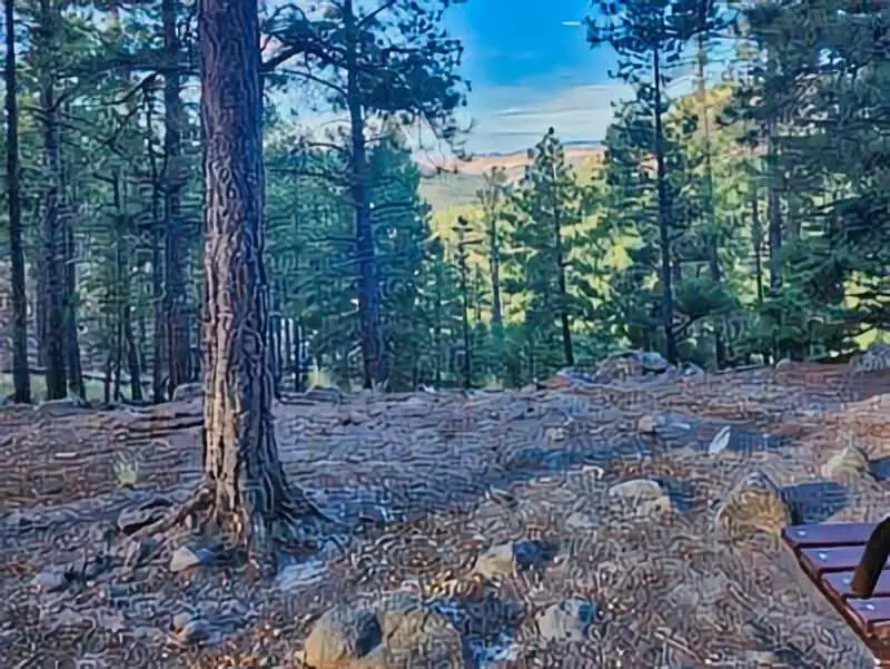
Jemez Paliza Campground lies off Forest Road 10 in the southern Jemez Mountains and offers both developed campsites and nearby opportunities for dispersed camping. Located in a wooded basin, this campground sits at an elevation of roughly 8,100 feet and features vault toilets, picnic tables, and fire rings. Water is not reliably available, so campers should come prepared.
Things to Do: The location is suited for hiking, wildlife observation, and short off-road drives through the forest. Due to its higher elevation and isolation, it’s a quiet spot popular with those seeking minimal crowding. Nearby forest roads provide access to scenic viewpoints and more secluded areas.
Directions: From NM-4, turn south onto Forest Road 10 near the town of Ponderosa and continue for about 10 miles. The road is graded gravel but becomes rougher closer to the campground.
Vehicle Access: Smaller RVs and trailers can access the campground itself, though maneuvering may be tight. For dispersed camping nearby, high-clearance vehicles are recommended. Wet weather can cause road conditions to deteriorate quickly, especially in shaded areas.
Paliza Goblin Colony Free boondocking locations Frequently Asked Questions
We have gathered important details about boondocking near the Paliza Goblin Colony. These include where to camp, rules to follow, safety tips, available facilities, seasonal limits, and how to protect the environment.
What are the top recommended Paliza Goblin Colony Free boondocking locations?
The best spots are usually on public land areas surrounding Paliza Canyon. Flat, open spaces with good access to trails are preferred. Sites near the main trailheads allow easy hiking access and are popular among campers.
Can you provide guidance on boondocking regulations in the Paliza Goblin Colony area?
Boondocking is allowed on certain public lands, but we must follow local rules. These often include camping limits of 14 days, no open fires during dry periods, and respecting private property boundaries. Checking with local ranger offices before camping is important.
How do I ensure my safety while boondocking in the vicinity of the Paliza Goblin Colony Free boondocking locations?
We should watch for sudden weather changes and carry enough water. It’s wise to let someone know our plans and expected return. Using bear-proof containers and avoiding wildlife contact also helps keep us safe.
What amenities can I expect at Paliza Goblin Colony Free boondocking locations?
Amenities are very limited or absent. We usually find no toilets, running water, or trash service. It’s essential to bring all supplies, pack out all trash, and be prepared for primitive conditions.
Are there any seasonal restrictions for Paliza Goblin Colony Free boondocking locations?
Yes, some areas close during wildfire season or heavy rain to protect the land. Winter access might be limited due to snow or icy roads. Checking seasonal closures with the forest service helps us avoid problems.
What are the best practices for Leave No Trace while boondocking in the Paliza Goblin Colony Free boondocking locations?
We should camp on durable surfaces to avoid damage. Waste must be packed out or buried properly.
Avoid disturbing plants or wildlife, and leave all natural objects as we found them.
Following these rules protects the area for future visitors.