


7 Agua Fria National Monument Boondocking Locations: If we’re looking for a quiet place to camp without the crowds, Agua Fria National Monument offers some great boondocking spots. The best areas to camp are along Bloody Basin Road and near Badger Springs, where dispersed camping lets us enjoy nature without strict rules or fees. These spots give us a chance to explore the beautiful desert landscape and nearby archaeological sites.
Getting to Agua Fria is a breeze since it’s just 40 miles north of Phoenix. We can find open spaces where our RV or tent fits comfortably, with plenty of room to spread out and relax. Plus, with the wide open desert around us, it’s a perfect setting for stargazing or just enjoying some peace and quiet.
Whether we want to camp near the trails or close to cultural sites like Pueblo la Plata, there’s something for just about any kind of outdoor adventure. If we’re after a simple, no-frills camping experience with beautiful desert views, this place delivers.
Description And Information About This Location
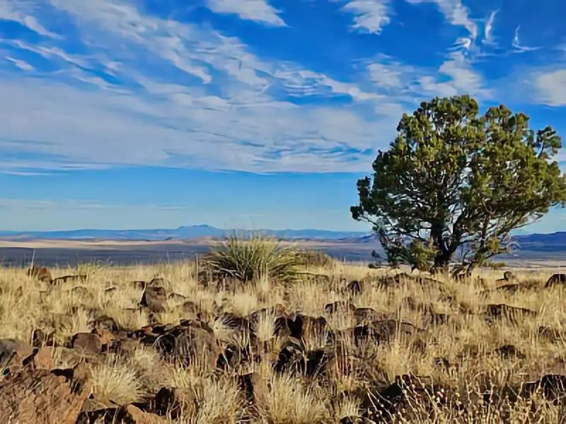
Agua Fria National Monument sits about 40 miles north of Phoenix, Arizona. It hugs the edge of the Colorado Plateau, so we get some pretty incredible views and unique landscapes to wander.
The elevation ranges from 2,150 to 4,600 feet, so we end up with a mix of desert and highland scenery. The monument’s wide-open vistas and river areas make peaceful, scenic spots to camp and boondock.
When we boondock at Agua Fria, we’re camping without services. That’s part of the charm—just us, the quiet, and the raw landscape. There are plenty of trails and petroglyphs to check out. Near Badger Springs (easy to reach from Interstate 17, exit 256), we’ll find a few popular boondocking options.
Here’s what we can expect at Agua Fria National Monument:
- Wide open spaces for hiking and off-grid camping
- Historical sites and petroglyphs to explore
- A mix of desert and plateau views
- Access from Phoenix in about an hour’s drive
We should bring plenty of water, plan for no cell service, and respect the natural and cultural features. That keeps Agua Fria special for everyone.
Location And Access
Agua Fria National Monument sits in central Arizona, mainly in Yavapai County, with a bit stretching into Coconino County. It’s a favorite for boondockers who want quiet, open spaces and beautiful desert views.
We get there by heading north from Phoenix on Interstate 17. The monument is about 40 miles out, so it’s a quick trip that feels like a real escape. The main access points are exit 256 at Badger Springs, exit 259 at Bloody Basin Road, and Cordes Junction.
If we take the Bloody Basin Road exit (259), we’ll find several free dispersed camping areas. These spots have plenty of room for RVs or tents, and the vibe is peaceful and natural. Buckskin Mountain is a good landmark to watch for.
Traveling along these routes is pretty straightforward. Interstate 17 is a well-kept highway. Once we’re off the highway, roads like Bloody Basin are gravel but usually passable for most vehicles.
Quick rundown on getting to Agua Fria National Monument for boondocking:
- From Phoenix, head north on I-17
- Take Exit 256 (Badger Springs) or Exit 259 (Bloody Basin Road)
- Follow signs toward camping areas near Buckskin Mountain
- Cordes Junction exit offers more dispersed spots
Easy access and quiet camping make Agua Fria a solid pick for our next adventure.
Directions: How To Get There And What To Expect
To reach Agua Fria National Monument, we start by driving north on Interstate 17 from Phoenix. Three main exits lead us in: Badger Springs (exit 256), Bloody Basin Road (exit 259), and Cordes Junction.
If we pick Bloody Basin Road, we’ll hit a rough dirt road that runs about 10 miles. High-clearance vehicles handle it best. This road takes us to a mesa with awesome canyon views.
Inside the monument, there’s no entry fee. We should plan our route ahead, since the area’s pretty big. Downloading a map or bringing a printed one is smart. That way, we know which trails and boondocking spots we want to check out.
The terrain can get rugged. We’ll want to prep for uneven surfaces and wide-open areas. There’s no water in the monument, so packing enough supplies is non-negotiable.
Quick guide:
| Step | Details | Tips |
|---|---|---|
| Start point | Phoenix, AZ | Interstate 17 northbound |
| Access exits | Badger Springs (256), Bloody Basin (259), Cordes Junction | Use high-clearance on dirt roads |
| Road type | Paved to exits, then dirt roads | Check vehicle suitability |
| Fees | None | Free entry |
| What to bring | Water, food, map, camping gear | Cell signal might be weak |
Stay safe and enjoy the quiet, wide-open spaces out here.
Amenities And Activities
When we boondock at Agua Fria National Monument, the experience is about as natural and simple as it gets. Campsites are primitive—no hookups or fancy amenities. There are vault toilets nearby, which is a nice touch.
We’re free to pick our own spot, but sticking to existing sites helps protect the land. This way, we can enjoy quiet nights under the stars and avoid the crowds.
There’s plenty to do. We can hit scenic trails or check out historic sites. Wildlife watching is a big draw. If we want to get more active, four-wheel driving, biking, and bird-watching are all on the table.
Popular activities here:
- Hiking
- Bird-watching
- Boondocking
- Wildlife viewing
- Scenic drives
Bringing enough water and supplies is crucial since services are almost nonexistent. This is real boondocking—just us, nature, and the open sky.
The landscape’s gorgeous, with chances to spot big game animals. If we want a quiet stay without crowds, and time to soak up nature at our own pace, it’s hard to beat.
Camping Regulations And Restrictions
Camping at Agua Fria National Monument comes with a few important rules. There aren’t any developed campgrounds—just dispersed or boondocking sites. We set up camp in undeveloped areas.
We can stay up to 14 days in one spot. After that, we should move along to let the land recover and give others a chance to enjoy it. Staying longer than two weeks in the same place isn’t allowed.
Set up camp at least 200 feet away from water sources to help protect wildlife and keep water clean. Whenever possible, use campsites that have already been used to minimize our impact.
Campfires are allowed, but only if there aren’t fire restrictions. We can use generators, but it’s good manners to keep noise down for other campers.
Keep vehicles on designated roads or trails. Driving off-road damages the land and plants. And don’t forget to follow all hunting and firearms laws while in the monument.
Following these rules keeps Agua Fria beautiful and open for everyone.
Leave No Trace
Camping in Agua Fria National Monument means we need to keep things clean for everyone. We always pack out what we bring in—no trash or gear left behind.
We set up camp at least 200 feet from water sources. That helps protect the water and the animals relying on it. If there’s an established spot, we use it.
We avoid digging new fire pits or messing with plants. Stick to established fire rings if fires are allowed. Otherwise, cook with a camp stove.
Leaving No Trace means we leave the place as natural as we found it. We respect the land and wildlife. Our small choices keep Agua Fria beautiful for whoever comes next.
Quick checklist:
| Leave No Trace Tips | Why It Matters |
|---|---|
| Pack out all trash | Keeps the area clean |
| Camp 200 feet from water | Protects water and wildlife |
| Use existing campsites | Minimizes new impact |
| Use existing fire rings or stoves | Prevents wildfires and damage |
| Respect plants and animals | Maintains natural habitat |
If we all pitch in, the monument stays safe and enjoyable.
Helpful Information Links
Bureau of Land Management
Recreation.Gov
National Park Service
Arizona Park Service
Arizona Trust
Arizona Fish and Game
Over 10,000 Free Boondocking Locations
Boondocking Recipes for 1000’s Of Camping Meals

Agua Fria National Monument Boondocking Locations
Free Boondocking Campgrounds
Cherry Boondocking Area
34.5418, -112.08325
Situated in the Cherry area of Arizona, this boondocking site is located within the Prescott National Forest, offering a rugged terrain with scattered vegetation. The area is known for its natural beauty and provides a primitive camping experience without developed facilities. Campers can enjoy the solitude and tranquility of the forest, making it an ideal spot for those seeking a quiet retreat in nature. The elevation and forested surroundings contribute to cooler temperatures, especially during the summer months.
Things to Do:
Nearby attractions include the Prescott National Forest, which offers numerous hiking and exploration opportunities. Additionally, Montezuma Castle National Monument is in the vicinity, providing a chance to explore ancient cliff dwellings and learn about the region’s history. The area is also suitable for bird watching and enjoying the diverse flora and fauna of the region.
Directions:
From Camp Verde, take State Route 260 west towards Cottonwood. Turn south onto Cherry Road and continue for approximately 7 miles to reach the Cherry area. The boondocking sites are located along the forest roads branching off Cherry Road. It’s advisable to use a map or GPS to navigate the forest roads.
Vehicle Access:
The roads leading to the boondocking sites are unpaved and can be rough. High-clearance vehicles are recommended, especially during or after inclement weather. Large RVs and trailers may find it challenging to navigate the narrow and uneven forest roads. It’s advisable to scout the area ahead if you’re unsure about the road conditions.

Mayer Camp Area
34.37066, -112.27099
Situated near Mayer, Arizona, this boondocking area lies in a wide-open desert setting with sparse vegetation and minimal shade. The land is managed by the Bureau of Land Management and offers a dispersed camping setup. There are no services or amenities on-site, so campers must come fully self-contained. The site is relatively quiet and attracts those who prefer seclusion and scenic desert surroundings.
Things to Do:
Outdoor activities in the area include off-road driving, hiking, and rockhounding. The nearby town of Mayer has a few shops and places to restock supplies. To the west, Prescott National Forest offers forested trails, picnic areas, and scenic drives. Arcosanti, an experimental town and architectural site, is located a short drive south and offers tours and a look into sustainable living concepts.
Directions:
From Interstate 17, take Exit 262 for Cordes Lakes Road and turn west. Continue for about 1.5 miles, then turn south onto Antelope Creek Road. Follow this road for approximately 2 miles. Dispersed camping areas can be found on either side of the road past the cattle guard. Keep an eye out for flat pull-offs and already established campsites.
Vehicle Access:
The access road is a maintained dirt road, suitable for most vehicles during dry conditions. However, it can become muddy and difficult to traverse in wet weather. Small to medium-sized RVs and trailers typically have no issue, but longer rigs should proceed with caution due to limited turning space in some pull-off areas.

Agua Fria BLM
34.232881, -112.021196
Situated within the Agua Fria National Monument, this BLM-managed area provides wide-open spaces, rolling hills, and desert vegetation. The landscape includes high desert terrain with juniper trees and tall grasses. This boondocking location is fully undeveloped with no amenities or water, catering to self-sufficient campers looking for isolation and rugged beauty.
Things to Do:
Popular activities include hiking the surrounding mesas and canyons, exploring petroglyphs left by ancient cultures, and visiting nearby historic mining sites. The monument also contains archaeological sites and remnants of ancient settlements. Wildlife viewing is another draw, with chances to see antelope, javelina, and a variety of bird species. The closest services are found in Cordes Lakes and Black Canyon City.
Directions:
From Interstate 17, take Exit 259 for Bloody Basin Road and head east. Continue on Bloody Basin Road (Forest Road 269) for several miles. Boondocking spots can be found along the way, especially once you enter the designated monument area. Stay on established roads and use pull-offs that show signs of previous use.
Vehicle Access:
Access is via a dirt road that is manageable in dry weather. High-clearance vehicles are strongly recommended. The road may be impassable after rain due to slick and muddy conditions. Larger rigs can make it, but scouting ahead on foot is advised before committing to a site, especially on narrower paths or uneven areas.

Crown King Road
34.296318, -112.138756
Situated along Crown King Road in central Arizona, this boondocking location lies between the town of Cleator and the mountain community of Crown King. The route traverses steep terrain and pine-covered hillsides as it climbs into the Bradshaw Mountains. This area is known for its cooler temperatures and pine-scented air. Camping is dispersed and primitive with no services, attracting those looking for remote forest camping.
Things to Do:
Nearby outdoor activities include hiking, exploring old mining trails, off-roading, and mountain biking. Crown King is a small historic town offering a general store, saloon, and seasonal lodging. The journey to Crown King itself is an adventure, with panoramic views of the Prescott National Forest and plenty of stops for photography. Wildlife sightings are common, including elk and deer.
Directions:
From Interstate 17, take Exit 248 for Bumble Bee Road and follow signs toward Crown King. The road becomes Forest Road 259 (Crown King Road) and winds through rugged terrain for about 25 miles. Boondocking opportunities exist along this route. Use pull-outs and clearings that have been previously used to avoid damaging vegetation.
Vehicle Access:
Crown King Road is a challenging drive, especially in wet weather. The road is unpaved, narrow in places, and includes steep switchbacks. High-clearance 4×4 vehicles are recommended. Travel trailers and large RVs are not advised on this route due to the rough conditions and limited space for turning.
Agua Fria National Monument Boondocking
34.237897, -112.108923
Situated within the Agua Fria National Monument, this boondocking site offers a rugged and undeveloped environment characterized by high desert terrain, rolling hills, and sparse vegetation. The area is managed by the Bureau of Land Management and provides dispersed camping opportunities without developed facilities. Campers seeking solitude and a connection with nature will find this location appealing. The monument encompasses over 70,000 acres and features archaeological sites, including ancient petroglyphs and ruins, offering a glimpse into the region’s rich history.
Things to Do:
Visitors can explore various hiking opportunities, such as the Badger Springs Trail, which leads to the Agua Fria River and showcases petroglyphs along the way. The monument also contains sites like Pueblo la Plata, an ancient settlement accessible via Bloody Basin Road. Wildlife viewing is popular, with chances to see species like javelinas, deer, and various bird species. The area’s remote nature makes it ideal for stargazing and photography.
Directions:
From Interstate 17, take Exit 256 for Badger Springs Road or Exit 259 for Bloody Basin Road. For Badger Springs, follow the gravel road east for approximately one mile to reach the trailhead parking area. For access to Pueblo la Plata, take Bloody Basin Road east for about 8.3 miles, then turn north onto an unmarked dirt road and continue for approximately one mile. High-clearance vehicles are recommended, especially beyond the initial graded sections.
Vehicle Access:
Access roads are primarily unpaved and can be rough, particularly beyond the first few miles. High-clearance vehicles are necessary for navigating these roads, especially after inclement weather. Larger RVs may find it challenging to maneuver due to narrow paths and uneven terrain. It’s advisable to check road conditions before traveling.

Bumblebee BLM
34.137554, -112.147808
Situated near the historic town of Bumble Bee, Arizona, this BLM-managed boondocking site offers a high desert environment with open spaces and minimal vegetation. The area provides dispersed camping without developed facilities, catering to campers seeking a remote and quiet experience. The landscape features rolling hills and is popular among off-highway vehicle enthusiasts due to its proximity to various trails.
Things to Do:
Outdoor activities include off-roading, hiking, and exploring the surrounding desert terrain. The nearby town of Bumble Bee offers a glimpse into Arizona’s mining history, with remnants of old structures and a rustic atmosphere. Wildlife viewing is possible, with sightings of species like coyotes, jackrabbits, and various birds. The area’s elevation provides cooler temperatures compared to the lower desert regions.
Directions:
From Interstate 17, take Exit 248 for Bumble Bee/Crown King Road and head west. Continue on Bumble Bee Road for approximately 2.5 miles to reach the dispersed camping areas. The road is unpaved but generally passable for most vehicles in dry conditions. Look for established pull-offs and clearings that have been previously used for camping.
Vehicle Access:
The access road is a maintained dirt road suitable for most vehicles during dry weather. However, it can become muddy and challenging to navigate after rain. High-clearance vehicles are recommended, especially for exploring deeper into the area. Large RVs and trailers may find limited space for turning and leveling, so caution is advised.
Paid Campgrounds

Hazeltt Hollow Campground
34.170071, -112.285408
Situated within the Prescott National Forest near the Horsethief Basin area, Hazlett Hollow Campground offers a semi-primitive camping experience surrounded by ponderosa pine forests. The campground features 15 campsites equipped with picnic tables, fire rings, and three-sided wooden shelters with concrete floors. Vault toilets and drinking water are available on-site. The area is known for its historical significance, with many structures built by the Civilian Conservation Corps in the 1930s.
Things to Do:
Recreational activities include hiking, fishing in nearby Horsethief Lake, and exploring the forested trails. The campground’s elevation provides cooler temperatures, making it a popular retreat during the summer months. Wildlife viewing opportunities abound, with chances to see deer, elk, and various bird species. The area’s rich history adds an educational aspect to the camping experience.
Directions:
From the town of Mayer, take Main Street east to the junction with Antelope Creek Road. Continue southeast on this road for approximately 9 miles to Cordes. From Cordes, take Forest Road 259 to Crown King. At Crown King, take Forest Road 259A south for 0.5 miles to the junction with Forest Road 52. Follow Forest Road 52 southeast for about 6 miles to reach Hazlett Hollow Campground.
Vehicle Access:
Access roads are primarily unpaved and can be narrow and winding, especially as you approach the campground. High-clearance vehicles are recommended, and caution is advised for larger RVs and trailers due to limited maneuvering space. The roads can become challenging after inclement weather, so checking conditions beforehand is advisable.
Cost:
The campground operates on a first-come, first-served basis with a fee of $10 per night per site. An additional fee of $5 applies for extra vehicles. Payment is accepted via self-pay stations that only accept cash or checks
Frequently Asked Questions
Boondocking at Agua Fria National Monument means we need to know where to camp, what rules to follow, and what we can do. Being prepared makes the trip better.
How can I find boondocking locations within Agua Fria National Monument?
We can pick from plenty of undeveloped areas to camp inside the monument. It’s best to use spots that are already established. Staying at least 200 feet from water sources keeps things healthy for the land.
Are there any maps available for boondocking areas around Agua Fria National Monument?
Yep, maps are available at local ranger offices or online. Some websites and apps show dispersed camping spots and roads like Bloody Basin Road, which is a favorite among campers.
What are the rules and regulations for camping at Agua Fria National Monument?
Camping is allowed for up to 14 days in undeveloped areas. We need to set up at least 200 feet from water sources. There aren’t any facilities, so we pack out all trash and follow Leave No Trace.
Can I camp anywhere I want within a National Monument in Arizona?
We can camp on undeveloped land, but not everywhere. Some spots are off-limits to protect plants and animals. Using existing campsites and following posted rules helps avoid damage.
What should I be aware of when boondocking at Agua Fria National Monument?
There are no bathrooms or water, so we need to bring our own supplies. The weather can turn quickly, so be ready for heat or cold. Respect wildlife and keep a safe distance—for their sake and ours.
What activities are popular at Agua Fria National Monument for those who boondock?
A lot of us head out for hiking, bird watching, or poking around petroglyph sites. The place gets really quiet at night, and the dark skies? Perfect for stargazing if you’re into that. Some folks like to try off-road driving in certain spots, but you’ve got to stick to the marked routes and take it slow.