


Lake Powell Boondocking Locations Guide for Adventurous Campers: So, you want to camp at Lake Powell without the fees and crowds? Boondocking might just be your ticket. There are several free dispersed camping spots scattered around Lake Powell—think Lone Rock Canyon, Ice Cream Canyon, and Navajo Canyon. These places let you settle in right by the water, away from the chaos, surrounded by the kind of scenery that makes you want to stay out late stargazing.
Boondocking here means you’re on your own—no hookups, no bathrooms, not even a trash can most of the time. You’ll need to bring your own supplies and be ready to rough it a bit. But that’s the tradeoff: peace, quiet, and a dose of nature that’s hard to beat.
If you pick one of Lake Powell’s boondocking spots, you’ll wake up to wild views and have hiking or boating right at your doorstep. It’s a chance to really explore the area, save some cash, and maybe even find a little solitude.
Description And Information About This Location
Lake Powell stretches along the Colorado River, hugging the edge of Glen Canyon National Recreation Area. Most campsites out here are primitive—no frills, no hookups. Some are tucked right along the shoreline, so you can jump straight into the water for a swim or launch your kayak without much fuss.
There’s a whole maze of side canyons and slot canyons nearby, including the ever-popular Antelope Canyon. If you’re up for a hike or want to explore by boat, don’t forget a good map—these canyons are easy to get lost in.
You’ll spot the Glen Canyon Dam near the lake, controlling the water levels. It’s worth a visit if you’re in the area. And yeah, Horseshoe Bend is close by too, with its famous curve in the Colorado River.
Don’t expect to build a campfire just anywhere—most sites don’t allow open fires, though some have grills. A handful of developed campgrounds offer basics like potable water and restrooms, but if you’re boondocking, you’ll probably go without. Quiet hours usually run from 10 pm to 6 am, which keeps things mellow.
If you love the outdoors, there are plenty of trails and natural bridges to check out. The landscape here is all red rocks meeting blue water—honestly, it’s a bit surreal.
Location And Access
You’ll find boondocking spots on both the Arizona and Utah sides of Lake Powell. Some of the favorites: Lone Rock Beach in Arizona and Bullfrog in Utah. Both offer free dispersed camping and easy water access.
Want to be closer to civilization? Page, Arizona and Wahweap are options, with Wahweap offering more developed campgrounds if you decide you need a shower.
Lone Rock Campground sits right on the sand—no reservations, just show up and hope there’s space, especially in peak season.
Bullfrog takes you through Glen Canyon National Recreation Area, passing Lees Ferry and Antelope Point Marina. There are a few camper-friendly spots, but most are dispersed and pretty basic.
Most of these areas need a high-clearance vehicle, especially if you’re leaving the pavement. Sometimes you’ll have to hike or even boat in.
Here’s a quick access rundown:
| Location | Access Type | Notes |
|---|---|---|
| Lone Rock Beach | Paved road, easy | High demand, no hookups |
| Wahweap | Paved road, easy | Developed campground |
| Bullfrog | Gravel & dirt roads | Dispersed camping, fewer amenities |
| Lees Ferry | Paved & gravel road | Access to water and trails |
| Antelope Point Marina | Paved road, easy | Close to boat launches |
Check the roads before you go, especially after rain—some spots turn to mud or get washed out.
Directions: How To Get There And What To Expect
Getting to Lake Powell’s boondocking areas is pretty straightforward. Start on I-17 or I-40, then take US-89 North toward Glen Canyon Dam. Once you cross the dam, it’s less than a mile before you’ll see signs or turnoffs for dispersed camping.
If you’re hauling a boat or just want the easiest access, head for Antelope Point Marina. It’s close to a bunch of free campsites, but for the more remote spots, you might need a boat to get there.
There’s an entrance fee for Glen Canyon National Recreation Area, and if you’re launching a boat, you’ll need a separate pass. Pets are usually welcome on a leash, but double-check the local rules.
Some roads to the campsites get rough—unpaved, rutted, and occasionally a little sketchy. Bring a high-clearance vehicle if you can. Stock up on water, food, and fuel, because services are thin out here.
Don’t expect hookups, trash bins, or restrooms at dispersed sites. You’ll need to pack everything out and stick to Leave No Trace. Cell service? Maybe, maybe not—don’t count on it.
Key points:
| Step | Details |
|---|---|
| Main roads | I-17, I-40, US-89 North |
| Access point | Antelope Point Marina |
| Fees | Entrance and boating passes needed |
| Vehicle | High clearance recommended |
| Amenities | None at dispersed camping sites |
Amenities And Activities
Boondocking at Lake Powell means you’ll mostly be relying on your own gear. Most dispersed camping spots don’t have hookups, so bring plenty of water and whatever you need for power. A few campgrounds have picnic tables, grills, or potable water, but don’t count on it.
If you’d rather have hookups, showers, and WiFi, Lake Powell RV Park and a couple others offer those comforts. They even have laundry and modern bathrooms. But if you’re after the off-grid vibe, dry camping is the way to go.
Bring your kayak or small boat—lots of campsites let you launch right from shore. Lone Rock Beach Campground is a favorite for boondockers who want to be close to the water.
Quiet hours usually run 10 p.m. to 6 a.m. Fires are often restricted, so check before you light one. Some campgrounds have grills you can use. Showers, if available, are usually coin-operated and sometimes have time limits (so don’t expect a spa day).
You’ll have plenty to do: hiking, fishing, paddling, or just soaking up the view.
Camping Regulations And Restrictions
You can camp just about anywhere along Lake Powell’s shorelines—just steer clear of marinas and developed recreation areas. That leaves you with plenty of primitive spots right by the water.
No permits or camping fees for undeveloped areas, but you’ll still pay to enter the park and for vessel use if you’re boating in.
Don’t camp near established campgrounds, picnic spots, or trailheads. Pick a spot well away from these to stay within the rules.
Keep your impact low: pack out your trash and don’t mess with the plants or wildlife. That’s just good camping manners.
Bring a solid map of Glen Canyon. Knowing the lay of the land will help you stay safe, legal, and maybe even find a hidden gem or two.
Leave No Trace
Boondocking at Lake Powell comes with some responsibility—Leave No Trace is the name of the game. That’s how we keep this place wild for everyone who comes after.
Take all your trash and leftovers with you. Don’t burn or bury anything. If fires are allowed, use established rings and make sure they’re dead out before you leave.
Don’t trample plants or mess with wildlife. Stick to existing roads and campsites to avoid making new scars on the land. Cutting live vegetation or moving rocks? Let’s not do that.
Handle human waste the right way. If there’s a restroom, use it. If not, dig a hole 6-8 inches deep, at least 200 feet away from water.
Respect quiet hours and give other campers a little space. Nobody likes being woken up at sunrise by someone else’s playlist.
If we all pitch in, Lake Powell will stay awesome for a long time.
Helpful Information Links
Bureau of Land Management
Recreation.Gov
National Park Service
Arizona Park Service
Arizona Trust
Arizona Fish and Game
Over 10,000 Free Boondocking Locations
Boondocking Recipes for 1000’s Of Camping Meals

Glen Canyon Boondocking Locations

Glen Canyon Dam Bridge – Arizona Boondocking
36.935195, -111.477805
Glen Canyon Dam Bridge Boondocking offers a striking desert backdrop with views overlooking Lake Powell and the Colorado River. Located near Page, Arizona, this spot provides free dispersed camping near the iconic Glen Canyon Dam. It’s a convenient option for travelers who want to experience the Glen Canyon National Recreation Area without committing to a developed campground. The open terrain offers level spots for RVs, vans, and tents, though the area has limited shade and no on-site facilities.
Things to Do:
The Glen Canyon area offers excellent sightseeing and photography opportunities, particularly from the nearby Glen Canyon Dam Bridge overlook. Visitors can take short drives to access Horseshoe Bend, Antelope Canyon, and Lake Powell. The Carl Hayden Visitor Center is also nearby, providing educational displays about the dam and regional geology. Boaters, hikers, and anglers will find several recreational options in the surrounding public lands.
Directions:
Use GPS coordinates 36.935195, -111.477805 to navigate to the site. The boondocking area is located just off Highway 89, with easy access for all vehicle types.
Vehicle Access:
This location is accessible to all standard vehicles, including RVs and travel trailers. The surface is compacted dirt and gravel. There are no amenities, so campers should be prepared to be fully self-contained. Due to its proximity to Page, this site can fill up quickly during peak tourist seasons. Cell service is generally strong in this area.

Glen Canyon NRA West – Arizona Boondocking
36.994201, -111.60102
Glen Canyon NRA West offers a remote yet scenic boondocking opportunity inside the boundaries of the Glen Canyon National Recreation Area. The location is west of Page, Arizona, and allows campers to immerse themselves in the quiet desert environment. The area consists of open BLM land with views of mesas, sandstone formations, and desert washes.
Things to Do:
This boondocking site serves as a good base for exploring Glen Canyon NRA and nearby Lake Powell. Outdoor enthusiasts can enjoy hiking, off-roading, stargazing, and photography. Given its remote nature, it also offers an escape from the more crowded areas near the lake. Boat launches at Wahweap and Lone Rock Beach are within driving distance, and the region is also home to lesser-known geological features and slot canyons.
Directions:
Use GPS coordinates 36.994201, -111.60102. Access is typically via dirt roads leading west from Highway 89. Some areas may require higher clearance vehicles depending on road conditions, especially after rain.
Vehicle Access:
This site accommodates RVs, vans, and tents, though access roads can be rough and may become impassable in wet weather. There are no amenities on-site, and campers must pack out all waste. Cell reception is spotty depending on the carrier. It’s advised to check weather and road conditions before heading in.

Boondocking White Pocket Campground
36.954567, -111.893695
White Pocket is one of the more remote and visually unique boondocking destinations in northern Arizona. Located on the Paria Plateau within Vermilion Cliffs National Monument, this site provides direct access to incredible rock formations and landscapes that attract photographers and hikers from across the country. The area features swirled sandstone, colored rock mounds, and formations similar to The Wave—without the permit requirement.
Things to Do:
Visitors to White Pocket can explore the surrounding geological formations on foot. Hiking, nature photography, and stargazing are popular activities here. Because of the isolation, the night sky views are exceptional. The region is also home to desert wildlife and offers peaceful solitude for those willing to make the journey.
Directions:
Use GPS coordinates 36.954567, -111.893695. Reaching White Pocket requires traveling through deep sand and rough roads. A high-clearance, four-wheel-drive vehicle is absolutely necessary. There are no road signs, and GPS service may be unreliable, so paper maps or downloaded directions are recommended.
Vehicle Access:
Access is limited to high-clearance 4WD vehicles. This location is not suitable for large RVs or standard vehicles. There are no amenities, and all campers must be fully self-contained. Because of its remoteness, visitors should carry extra water, food, and emergency supplies. Weather conditions can change quickly and impact access roads.
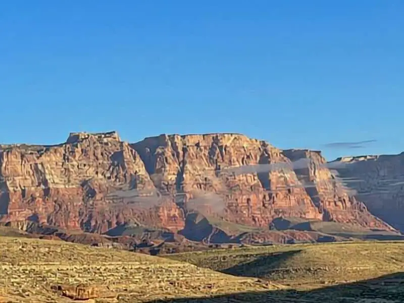
Badger Creek – Marble Canyon Boondocking
36.77642, -111.659206
Badger Creek offers a secluded and quiet boondocking area just outside of Marble Canyon, Arizona. This location is tucked away on BLM land near the Navajo Bridge and the Colorado River. The terrain is wide open and mostly flat, making it suitable for RVs and tent campers seeking privacy and expansive desert views.
Things to Do:
Nearby attractions include Marble Canyon, Lee’s Ferry, and the Colorado River. Visitors can enjoy hiking, birdwatching, photography, and fishing. Lee’s Ferry is a well-known starting point for rafting trips into the Grand Canyon. The surrounding Vermilion Cliffs create a striking backdrop for outdoor activities and relaxation.
Directions:
Use GPS coordinates 36.77642, -111.659206. Access is via dirt roads branching off Highway 89A. Roads are generally passable with regular vehicles, but recent weather can impact conditions.
Vehicle Access:
Accessible by cars, vans, and smaller RVs, though large rigs should scout ahead due to narrow sections. The surface is a mix of dirt and gravel. There are no facilities, so campers must bring all needed supplies and be prepared to leave no trace. Cell reception varies, but is generally fair near the highway.
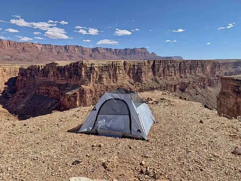
Marble Canyon Overlook – Arizona Boondocking
36.752823, -111.681285
The Marble Canyon Overlook boondocking area offers dramatic views of the canyon and Colorado River. This site is perched along the canyon rim and provides one of the most scenic free camping options in the region. Though primitive, the overlook is a favourite among photographers and campers seeking solitude with a view.
Things to Do:
The overlook offers access to scenic drives, hikes along the rim, and exploration of the Marble Canyon corridor. Visitors can take day trips to Lee’s Ferry, Navajo Bridge, and the Vermilion Cliffs National Monument. The area is excellent for sunrise and sunset photography, and the high vantage point provides panoramic views of the river gorge.
Directions:
Use GPS coordinates 36.752823, -111.681285. Access is via a dirt road off Highway 89A. While the road is passable for most vehicles in dry conditions, it can become slick and impassable after rain.
Vehicle Access:
Best for vans, small RVs, and tents. Larger vehicles may find limited turning space near the canyon edge. The site has no amenities and no shade, so campers should be prepared for full self-sufficiency. Campers must practice caution due to the proximity to steep drop-offs and lack of barriers.
Boondocking Vermilion Cliffs – Marble Canyon
36.75014, -111.71654
The boondocking area near Vermilion Cliffs and Marble Canyon offers sweeping views of some of Arizona’s most distinctive desert landscapes. Located along House Rock Valley Road just off U.S. 89A, this dispersed camping site sits in a quiet, remote setting with Vermilion Cliffs towering in the background. The location is part of the larger Vermilion Cliffs National Monument and lies not far from the Paria Plateau and the beginning of the Grand Staircase.
Things to Do:
This spot makes an ideal base for exploring nearby natural attractions such as the Navajo Bridge, Lee’s Ferry, and Marble Canyon. Hikers and off-roaders may also be interested in visiting White Pocket or trying to obtain a permit to hike The Wave. Wildlife viewing is common in this region, especially sightings of California condors, which are being reintroduced to the area. Sunrise and sunset bring vivid colours to the cliffs, making it an excellent location for photography and nature watching.
Directions:
Use GPS coordinates 36.75014, -111.71654. Access is via House Rock Valley Road, a dirt road off Highway 89A between Marble Canyon and Jacob Lake. The road is usually passable for most vehicles when dry but can become impassable after rain. Always check current conditions before setting out.
Vehicle Access:
This boondocking area is suitable for vans, 4WD vehicles, and small to mid-sized RVs. Larger rigs should proceed with caution, especially if weather has recently impacted road conditions. There are no amenities—no water, no toilets, no trash removal—so campers must be fully self-contained. Cell service is limited to non-existent in most areas, so plan accordingly. This is a true off-grid experience surrounded by open desert and towering red rock cliffs.
Frequently Asked Questions
There are several boondocking spots near Lake Powell with remote, no-frills camping. Some are totally free, others have a few more rules. Knowing where to look makes the trip a lot smoother.
What are the best boondocking spots near Lake Powell?
The best spots? Usually those shoreline areas away from the marinas and a few backcountry roads you can reach with 4WD. They’re quiet and the views are top-notch. Check local maps for details—some of the best places aren’t marked with big signs.
Is dispersed camping allowed around Lake Powell?
Yep, you can camp in a lot of places around Lake Powell. Just avoid developed marina zones and stick to Leave No Trace. Watch for posted signs—rules can change.
Where can you find free camping areas in the vicinity of Lake Powell?
You’ll find free camping along the shorelines and on nearby public lands managed by the National Park Service or BLM. Online resources and campground guides are your friend here.
Are there any restrictions on RV camping around Lake Powell?
RVs are welcome in plenty of camping areas, but some of the wilder spots need 4WD to reach. Don’t park inside marina boundaries or on private land. Always check the site’s specific rules and size limits.
How can one obtain a map of camping areas around Lake Powell?
Grab a map at visitor centers or ranger stations, or just look online at the Glen Canyon National Recreation Area website. They’ll show you campsites, dispersed areas, roads, and any restrictions you need to know.
What should one know about tent camping regulations at Lake Powell?
You can usually pitch a tent along the shorelines, just steer clear of marinas and those marked, developed spots. If there’s already a site, go ahead and use it—don’t trample any delicate areas. Stick to park rules about campfires and cleaning up after yourself.