
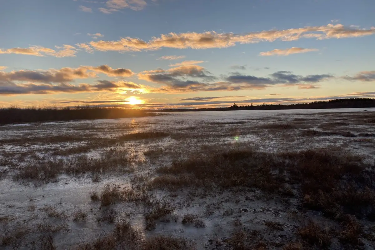
If you’re hoping to boondock near Sunkhaze Meadows National Wildlife Refuge, you’ll stumble across some quiet spots that let you really connect with nature—minus the usual campground crowds. The refuge has a handful of accessible places where you can park your rig and just soak up the peace among pine forests, wetlands, and winding streams.
The five best boondocking locations around Sunkhaze Meadows make it easy to hit trails, spot wildlife, and experience the unique peatland environment. You’ll find everything from gated forest roads to clearings near water, so you can pick your level of ruggedness or comfort.
About This Location
Sunkhaze Meadows National Wildlife Refuge sits in Milford, Maine, a bit north of Bangor. The place covers over 10,000 acres—yeah, it’s pretty big. You’ll wander through peat bogs, forests, and wetlands.
Evergreens and other trees create a patchwork of habitats for all sorts of wildlife. Streams and marshes wind through, making it a haven for birds, mammals, and aquatic critters.
It’s quiet out here. The natural setting is perfect for boondocking and wandering around. Trails snake through the woods, and you can watch nature do its thing, far from the noise of busy campgrounds.
The refuge was set up in 1988 to protect these important ecosystems. With its size and variety, it’s a solid spot for hiking, bird watching, and primitive camping.
Don’t expect much in the way of facilities. Bring what you need and follow the rules—this place is meant to stay wild.
| Key Features | Details |
|---|---|
| Location | Milford, Maine |
| Size | Over 10,000 acres |
| Habitats | Peat bogs, forests, wetlands |
| Established | 1988 |
| Common Activities | Hiking, bird watching, camping |
Location And Access
Sunkhaze Meadows National Wildlife Refuge is in central Maine, near Milford. You’ll get there via County Road, which cuts through the area.
A few access points open up the refuge. Carter Meadow Road is a popular one—a gated, pine-lined road off County Road, just west of Little Birch Stream. This is where you’ll find wooded camping spots tucked away.
There’s parking on County Road, right across from the refuge, so you can start your adventure close to the main trails and peat bogs.
Short trails crisscross the area, like the Ash Landing Trail (about 0.3 miles), leading you to Sunkhaze Stream—a highlight of the wetland.
Key Access Info:
| Access Point | Description | Notes |
|---|---|---|
| Carter Meadow Road | Gated, wooded road | Good for quiet camping |
| County Road Parking | Across from refuge | Close to main trails |
| Ash Landing Trail | Short trail to Sunkhaze Stream | Easy walk, scenic views |
There aren’t many amenities, so plan to rough it. The refuge is mostly untouched land, not set up for big RVs or glamping. That’s kind of the point, right?
Directions: How To Get There And What To Expect
To find Sunkhaze Meadows National Wildlife Refuge, start in Milford, Maine. Take Route 2, hang a right onto County Road, and drive about 6.4 miles until you hit Carter Meadow Road—your entry to the refuge.
Carter Meadow Road is gated and winds through pine woods. You’ll pass some private camps, so keep an eye out and respect those spots. The road leads to a few access points that work well for boondocking.
It’s quiet out here, with sprawling peat bogs and free-flowing streams. Wildlife is everywhere, so bring binoculars and keep your eyes peeled for birds and other critters.
Facilities? Pretty much nonexistent. You’ll need to be self-sufficient—there’s no running water or hookups at boondocking spots. Whatever you pack in, pack out.
What to bring:
- Water and food
- Camping gear for remote areas
- Insect repellent and weather-appropriate clothes
Tips for the drive:
| From | Distance | Directions |
|---|---|---|
| Milford, ME | 6.4 miles | Route 2 → County Road → Carter Meadow Road |
Gravel roads and minimal signage are part of the adventure. Bring a map or GPS—you’ll need it.
Amenities And Activities
Don’t expect much in the way of developed amenities at Sunkhaze Meadows. The place is wild, with limited vehicle access and some areas only open to foot traffic. So yeah, you’ll need to be self-sufficient out here.
Wildlife watching is a big draw. Wetlands attract waterfowl and wading birds, and you might spot deer in the upland woods, especially when it’s cold. Binoculars and a camera are must-haves.
Short trails—like the Ash Landing Trail—let you poke around the peatlands and get close to Sunkhaze Stream. It’s a quick hike with plenty to see if you’re into nature observation.
Hunting is allowed, but the terrain is thick and access can be tough. You’ll have to hunt on foot; plan ahead if that’s your thing.
Key activities:
- Wildlife watching
- Short hikes
- Photography
- Primitive hunting (where permitted)
Water and restrooms aren’t a given, so haul in what you need. If you’re after peace, quiet, and a break from modern comforts, this is your spot.
Camping Regulations And Restrictions
Camping at Sunkhaze Meadows National Wildlife Refuge comes with some strict rules. You can’t camp or park overnight inside the refuge. This protects the peat bogs and wildlife.
Fires? Not allowed—no open flames anywhere in the refuge. It’s a wildfire risk and just not worth it.
If you’re hunting, you’ll need to follow state rules. Only non-toxic shot is allowed, and you’ll need proof of that, along with your hunting permits.
For camping nearby, dispersed camping is fine in some surrounding areas. You can stay up to 16 days in one spot, then you’ll have to move at least 5 road miles before camping again.
Campgrounds run by other agencies near the refuge might charge fees or require permits, so double-check before you roll in.
| Rule | Details |
|---|---|
| Camping inside refuge | Not allowed |
| Fires | Prohibited |
| Hunting equipment | Only non-toxic shot allowed |
| Dispersed camping duration | Up to 16 days per site |
| Move distance after camping | 5 road miles minimum before next site |
Stick to the rules and you’ll help keep the refuge wild and your visit hassle-free.
Leave No Trace
If you’re boondocking at Sunkhaze Meadows National Wildlife Refuge, Leave No Trace is non-negotiable. It’s about keeping the place beautiful for plants, animals, and everyone else.
Pack out everything—trash, food scraps, all your gear. Don’t leave a mess behind. Wildlife and other visitors will thank you.
Use established campsites or already-cleared spots when you can. Try not to trample plants or bother animals. Watch wildlife from a distance and never feed them.
If you’re allowed a fire, keep it tiny and use a fire ring (if there is one). Make sure it’s out cold before you leave—no one wants a wildfire.
Don’t leave camping gear or junk sitting out for more than 14 days. Let the next person enjoy a clean spot.
Keep it quiet. Loud noises mess with wildlife and ruin the peace for others.
Here’s a quick Leave No Trace checklist:
| Action | Why It Matters |
|---|---|
| Pack out all trash | Keeps wildlife and habitat safe |
| Use existing campsites | Protects plants and soil |
| Keep fires small & safe | Cuts wildfire risk |
| Respect local camping limits | Keeps things natural and open |
| Stay quiet | Lets animals and people relax |
If you do your part, Sunkhaze Meadows will stay wild and welcoming.
Information Resources
Acadia National Park, National Park Service (NPS)
U.S. Geological Survey (USGS)
Visit Boondocking Locations for over 10,000 boondocking opportunites in the United States.
Sunkhaze Meadows National Wildlife Refuge Boondocking Locations

Log Landing Boondocking
44.9574, -67.8727
Log Landing Boondocking is a primitive, riverside camping location situated near the Machias River in eastern Maine. Known for its connection to Maine’s logging history, the area provides peaceful overnight options for campers travelling through Washington County. This spot is suitable for those seeking a quiet basecamp near the Downeast Lakes region or paddling routes along the Machias River Corridor.
Things to Do:
The nearby Machias River offers canoeing, kayaking, and opportunities for freshwater fishing. The surrounding forests are home to deer, beavers, eagles, and songbirds. Hikers can explore sections of the Machias River canoe trail or access logging roads for nature walks and wildlife viewing. This site is also used by hunters and anglers during season.
Directions:
Use GPS coordinates 44.9574, -67.8727. The site is accessed from Route 9 via logging roads that may be unsigned. Conditions vary depending on weather—be prepared for remote travel and bring a printed map or GPS with offline access.
Vehicle Access:
The site is reachable by dirt and gravel roads. Best suited for high-clearance vehicles, truck campers, and small RVs. No amenities are present—bring your own water, sanitation supplies, and firewood. Open fires may be permitted with caution. Follow Leave No Trace principles and check if access fees apply. No cell service should be expected in the area.

Machias River Corridor PRL Rt 9 Boondocking
44.905921, -67.836207
The Machias River Corridor Public Reserved Land (PRL) along Route 9 in Maine offers free, dispersed camping in a remote and scenic setting. This area is part of a 76-mile canoe route featuring Class I-III whitewater, making it a popular destination for paddlers and outdoor enthusiasts. The corridor encompasses over 60,000 acres, with the Maine Bureau of Parks and Lands managing approximately 14,000 acres centered around First, Second, and Third Machias Lakes
Things to Do:
Campers can enjoy fishing for smallmouth bass, trout, and other species in the Machias River. The area is also excellent for wildlife observation, with opportunities to see moose, deer, and various bird species. Hiking and exploring the surrounding forested lands offer additional recreational opportunities. The corridor is part of a larger conservation effort that began in the 1990s and culminated in 2008 with the completion of the third phase of the Machias River Project .
Directions:
Use GPS coordinates 44.905921, -67.836207 to reach the site. Access is via gravel logging roads that are generally passable from June to October but require careful driving and a detailed map . The area is accessible from Route 9, with several campsites located along the river.
Maine
Vehicle Access:
The area is accessible via gravel roads; suitable for tents and small RVs. No amenities are available; campers must be self-sufficient and adhere to Leave No Trace practices. Camping is free and operates on a first-come, first-served basis .
This boondocking site offers a peaceful environment for campers seeking solitude and a connection with nature. The proximity to the river and surrounding forested lands makes it an ideal spot for various outdoor activities.
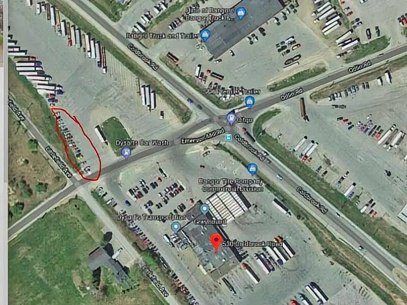
Dysarts Parking Lot Boondocking
44.7759, -68.86446
The nearby area offers access to basic amenities such as fuel, restrooms, and food. While not a recreational destination, it’s a suitable overnight pause point on longer routes. Bangor is less than 10 miles away, offering opportunities to explore the Penobscot Riverwalk, local shopping, and historic landmarks. The Kenduskeag Stream Trail provides hiking and birding within a short drive.
Directions:
Use GPS coordinates 44.7759, -68.86446. Access is direct from Coldbrook Road in Hermon, just off Exit 180 on I-95. Parking is located in the rear area of the truck stop lot.
Vehicle Access:
Flat, paved lot with ample space for RVs, vans, and trucks. No hookups or designated camping services are available. Overnight parking is generally allowed but campers should check in with store staff. Stay self-contained and follow posted rules. Noise from traffic and trucks may be present throughout the night.

Tunk Lake Area Boondocking
44.608675, -68.021493
The Tunk Lake Area in Hancock County, Maine, offers primitive camping near one of the state’s most pristine glacial lakes. Nestled between Donnell Pond and Spring River Lake public lands, this location is popular with outdoor enthusiasts looking for a secluded and scenic place to camp in eastern Maine.
Things to Do:
Campers have access to kayaking, canoeing, and fishing on Tunk Lake and surrounding waterways. The nearby trails, including the hike up Tunk Mountain, offer panoramic views of the Down East coastline. Wildlife watching is common in the area, with chances to see loons, deer, and even black bears. Swimming and berry picking are also seasonal options.
Directions:
Use GPS coordinates 44.608675, -68.021493. Access is via Route 182 between Franklin and Cherryfield. Look for gravel roads leading to primitive pull-off sites. Roads may be rough; use caution and avoid during wet conditions.
Vehicle Access:
Gravel road access with space for tents, vans, and small RVs. No facilities are present—campers must bring all essentials. Practice Leave No Trace ethics and pack out all waste. Camping is free and on a first-come, first-served basis. Cell service may be unreliable in parts of the area.

Schoodic Bay Boondocking
44.565119, -68.12768
Schoodic Bay Boondocking offers dispersed camping near the Schoodic Peninsula section of Acadia National Park. Located just outside the town of Gouldsboro, this site gives campers access to one of Maine’s most scenic coastal regions without the crowds found near Bar Harbor. It’s a quiet, undeveloped location with views of the bay.
Things to Do:
Visitors can enjoy paddling, clamming, and shoreline exploration along Schoodic Bay. The Schoodic Scenic Byway provides access to dramatic rocky coastlines, hiking trails, and cycling paths. Nature photography and birdwatching are excellent here, with views across the water and minimal light pollution at night for stargazing.
Directions:
Use GPS coordinates 44.565119, -68.12768. Access is via Route 1 or Route 186 through Gouldsboro, then along gravel roads to pull-off areas. Some roads may be seasonally maintained or require high-clearance vehicles.
Vehicle Access:
Unpaved access suitable for vans, truck campers, and small RVs. No services or facilities—campers must be fully self-contained. Fires may be restricted during dry periods. This site is ideal for boondockers seeking isolation and natural beauty with easy proximity to coastal exploration.
Frequently Asked Questions
You’ll find plenty of boondocking spots near Sunkhaze Meadows National Wildlife Refuge—something for everyone, really. Info on maps, how close you can camp, and other nearby areas like Moosehorn helps you plan. Trails and wildlife viewing make the trip even better.
What are the top boondocking spots near Sunkhaze Meadows National Wildlife Refuge?
Some of the best places are on forest roads and near wetlands around the refuge. Black Point Wildlife Drive is good for birdwatching and quiet camping. You’ll also find spots in nearby state forests where dispersed camping is allowed.
Is there a map available that shows boondocking locations around Sunkhaze Meadows National Wildlife Refuge?
Yep, plenty of online resources and apps like AllTrails show boondocking sites and hiking trails nearby. The U.S. Fish and Wildlife Service has maps for the refuge, but for boondocking, local forest service or camping websites are more helpful.
How close can you boondock to Sunkhaze Meadows National Wildlife Refuge?
You can set up camp within a few miles of the refuge’s edge, but you can’t camp inside the refuge itself. Most boondocking happens on public or state forest land around the refuge.
Are there any boondocking sites near Moosehorn National Wildlife Refuge?
Yes, Moosehorn National Wildlife Refuge has dispersed camping on nearby forest service roads. The landscape and wildlife are pretty similar to Sunkhaze Meadows, but check local rules—access and camping restrictions might be different.
What trails are accessible from boondocking locations around the Sunkhaze Meadows area?
Trails in the area include Black Point Wildlife Drive and others that wind through the forest and wetlands. Boondocking near these trails gives you easy hiking and good chances to spot birds and other wildlife.
Where can you find moose-viewing opportunities while boondocking in Maine?
If you’re hoping to catch a glimpse of moose while boondocking, check out the wetlands and forests around Sunkhaze Meadows or Moosehorn refuges. Honestly, your best bet is to head out early in the morning or just before dusk—those boggy, marshy spots seem to attract them most.