
height=”50″ class=”alignnone size-full wp-image-13668″ />

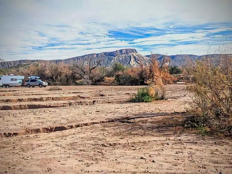
18 Theodore Roosevelt Lake Boondocking Locations: If you’re hunting for boondocking spots around Theodore Roosevelt Lake, you’ve got some solid options for free or low-cost camping. Lots of dirt roads near the lake’s south end open up to dispersed camping—just pull off, park, and settle in. No assigned sites, no fees, just you and the wilderness.
Some of the best boondocking locations sit right across the road from the Theodore Roosevelt lakes south end, and Bulldog Canyon up by the north entrance is a favorite too. These Theodore Roosevelt lake spots let you camp in peace, close to the water, with plenty of room for tents or RVs—no packed campgrounds in sight.
Paid campgrounds are nearby if you want a few creature comforts, but honestly, the dispersed areas around Roosevelt Lake deliver a rugged, flexible camping vibe that’s tough to beat.
Description And Information About Theodore Roosevelt Lake
Theodore Roosevelt Lake sits inside the Tonto National Forest, about 80 miles northeast of Phoenix. The Salt River feeds it, and it’s the biggest lake entirely within Arizona. Boaters, anglers, and water lovers flock here.
Scattered around the Theodore Roosevelt lake, you’ll find a mix of day-use and camping areas, plus boat launches like Indian Point and Roosevelt Marina. Most campgrounds here stick to the basics, so you get a stripped-down, natural camping experience.
The forest wraps the lake in a mellow, scenic setting. Not far off, Tonto National Monument adds a historical twist with ancient cliff dwellings—a cool side trip if you’re into old ruins and desert history.
Boondocking here means you’re on your own for most things, so come ready. Bring more water and supplies than you think you’ll need. If you’re after outdoor recreation in a raw, rustic spot, this place really delivers.
Key features of this location:
| Feature | Description |
|---|---|
| Recreational Options | Boating, fishing, hiking |
| Campgrounds | Primitive, group and standard sites |
| Nearby Attractions | Tonto National Monument, Salt River |
| Forest | Part of the Tonto National Forest |
If you’re planning to camp near the Theodore Roosevelt lake or just explore, it helps to know about the water access points and boat ramps scattered around the lake. You can get to the water from several spots, which is handy for fishing or launching a kayak.
Location And Access
You’ll find Theodore Roosevelt lake in central Arizona, tucked inside Tonto National Forest. The lake, created by the Theodore Roosevelt Dam on the Salt River, is reachable from a few main roads.
To get to the main boondocking areas for Theodore Roosevelt lake, most folks take State Route 188. Popular access points include Cholla Recreation Site and Indian Point—both near the lake and with easy routes to open camping areas (no hookups, of course).
Most boondocking happens off dirt roads or in simple parking spots near the shore. Services are pretty limited, and the terrain can get rough, especially after rain. Four-wheel drive or a high-clearance vehicle? Not a bad idea.
Here are a few key spots around the lake:
| Location | Description | Access Notes |
|---|---|---|
| Indian Point | Boat launch and camping areas | Easy access from paved road |
| Cholla Recreation Site | Large lakeside camping | Gravel roads, some rough spots |
| Roosevelt Marina | Full-service boating facility | Paved access, nearby parking |
| Windy Hill | Group sites and remote spots | Dirt road, some rough terrain |
The Theodore Roosevelt Dam anchors the lake’s western end—a decent landmark if you’re trying to get your bearings. Some camping areas near the dam might have sketchy access due to security or maintenance, so double-check before heading that way.
Plan your route before you go. Cell service drops out in places, so don’t count on your phone for last-minute directions.
Theodore Roosevelt Lake: How To Get There And What To Expect
Starting in Phoenix? Take State Highway 87 (the Beeline) north for about 60 miles.
At the junction with State Highway 188, hang a right. Stay on Highway 188 for another 26 miles or so, and you’ll be in the thick of Roosevelt Lake and the surrounding forest roads.
Most boondocking spots cluster around the lake and near Forest Road 83. These areas sit close to the water and offer easy access to the Tonto National Forest.
Expect dirt or gravel roads as you approach dispersed camping sites. Some roads get narrow or bumpy, so take it slow—especially if you’re rolling in a big rig.
You won’t find hookups or facilities at these sites. Bring everything: water, food, and whatever gear you need. Don’t be surprised by spotty or zero cell coverage in the area.
At camp, you’ll usually have plenty of space to spread out. Many sites perch right by the lake, so you get killer views and can fish without a hike.
Quick breakdown for your route:
| Step | Details |
|---|---|
| From Phoenix | Take Highway 87 (Beeline Highway) north |
| At junction | Turn right onto Highway 188 |
| Continue | Follow Highway 188 about 26 miles |
| Final approach | Use Forest Road 83 for boondocking spots |
Pack for a rustic trip—no frills, just the basics.
Amenities And Activities
Most boondocking spots at Theodore Roosevelt lake are primitive campsites. Don’t expect much in the way of facilities—usually no running water, no hookups. You’ve gotta bring your own supplies, especially water and power.
Some nearby campgrounds near the Theodore Roosevelt lake area toss in basic amenities like toilets or potable water. Cholla Campground even has showers and a paved boat launch, which can be handy if you want to clean up or get your boat in the water. But honestly, showers are rare at most boondocking spots.
You can camp for free in certain areas around the lake, but these spots really keep it simple. You’ll need to be self-sufficient, but you’ll also get more peace and fewer crowds.
As for things to do? You’ve got plenty: boating, fishing, hiking—the usual suspects. Boat launches like Indian Point and Roosevelt Marina make it easy to get out on the water.
RVers can find dump stations near Cholla Campground, but most boondocking areas don’t offer much for big rigs or hookups.
Use this info to sketch out your stay, so you’re not caught off guard by the lack of amenities.
Camping Regulations And Restrictions
Camping near Theodore Roosevelt lake comes with a few rules. The big one: you can camp for up to 14 days at a time, whether that’s all at once or spread out between May 1 and September 30.
You’ve got to respect quiet hours from 10:00 pm to 6:00 am. Generators? Only allowed from 6:00 am to 10:00 pm—nobody wants to hear an engine all night.
Don’t dig, level, or mess with the ground. Just leave things as they are. Pack out your trash, and if you see a bin, use it. Otherwise, take your waste with you.
If you’re camping outside the designated sites, expect little to no services. Some areas might require a permit—always double-check. Stick to the “leave no trace” rule, and leave your site looking like you were never there.
Trailers are fine, but check size limits—like, Cholla Campground only allows trailers under 32 feet. Read the posted rules at each spot so you don’t get fined.
Sticking to these rules keeps the area nice for everyone. Plan ahead, follow the limits, and you’ll avoid headaches.
Leave No Trace
If you camp at Theodore Roosevelt Lake, leave no trace. That means haul out all your trash—don’t leave litter behind. Anything you bring in, you should take out.
Use fire rings if you see them. If you build a fire, keep it small and make sure it’s completely out before you leave. Don’t scatter ashes or leftover wood.
Don’t damage plants or dig trenches. Stick to established trails and campsites to help protect the landscape and prevent erosion.
If you need to take care of human waste, use the restrooms if they’re there. If not, dig a hole 6-8 inches deep and at least 200 feet from water.
Respect the wildlife. Don’t feed animals or leave food scraps around. Lock up your food and trash so critters don’t get into it.
Here’s a quick checklist:
| Leave No Trace Rules | What You Should Do |
|---|---|
| Pack out trash | Take all litter with you |
| Use established fire rings | Build fires only in safe spots |
| Protect plants and soil | Camp on durable surfaces |
| Dispose of waste properly | Use toilets or bury waste deeply |
| Respect wildlife | Keep food secured and do not feed |
Stick to these basics and you’ll help keep Roosevelt Lake wild and beautiful.
Helpful Information Links
Bureau of Land Management
Recreation.Gov
National Park Service
Arizona Park Service
Arizona Trust
Arizona Fish and Game
Over 10,000 Free Boondocking Locations
Boondocking Recipes for 1000’s Of Camping Meals

Theodore Roosevelt Lake Boondocking Locations
Free Boondocking Locations

Hog Canyon Overlook
33.74339, -110.967214
Situated within the Tonto National Forest near Young, Arizona, Hog Canyon Overlook offers dispersed camping with expansive views of surrounding canyons. The area features a few campsites equipped with fire pits and is suitable for both tents and small RVs. Campers are advised to practice Leave No Trace principles, as the site lacks developed facilities.
Boondocking Locations
Things to Do:
Visitors can explore the nearby Hog Canyon Trail, an 8.4-mile out-and-back trail near Gold Canyon, Arizona, considered moderately challenging and popular for birding and hiking. The area is also in proximity to the Sierra Ancha Mountains, offering additional hiking opportunities.
Directions:
From Globe, Arizona, take AZ-188 N for approximately 15 miles. Turn right onto AZ-288 N and continue for about 30 miles. Turn left onto Forest Road 487 and follow signs to Hog Canyon Overlook.
US Forest Service
Vehicle Access:
High-clearance vehicles are recommended due to the rugged terrain leading to the campsite. The road conditions may not be suitable for large RVs or trailers.

H – Z Wash
33.624193, -110.934556
Situated along the Upper Salt River within the Tonto National Forest, H-Z Wash offers a dispersed camping experience amidst scenic desert landscapes. The area provides opportunities for fishing and non-motorized boating due to its proximity to the river. While the site is not developed, it allows for easy access to recreational activities and is suitable for families or individuals seeking a quick escape.
Things to Do:
Visitors can engage in water-based activities such as fishing and kayaking on the Upper Salt River. The surrounding area offers impressive views of mountains, canyons, and wildlife, making it ideal for nature enthusiasts.
Directions:
From Roosevelt, Arizona, take AZ-188 N for approximately 10 miles. Turn right onto Forest Road 60 and continue for about 5 miles to reach H-Z Wash.
Vehicle Access:
The access road to H-Z Wash is unpaved and may be rough in certain areas. High-clearance vehicles are recommended, and campers should scout ahead before driving down dirt roads.
EADS Wash
33.619939, -110.956455
Located on the Upper Salt River within the Tonto National Forest, EADS Wash offers dispersed camping with river access. The site provides an accessible toilet building and trash receptacles. Campers should be aware that the area is prone to flash floods and should camp out of flood zones while monitoring weather conditions.
Things to Do:
EADS Wash is a popular spot for river rafting on the Upper Salt River. The surrounding area offers opportunities for mountain biking in the Pinal Mountains and hiking or horseback riding at Picketpost Mountain.
US Forest Service
Directions:
From Globe, Arizona, take US-60 E for approximately 5 miles. Turn left onto AZ-77 N and continue for about 10 miles. Turn right onto Forest Road 287 and follow signs to EADS Wash.
Vehicle Access:
The access road to EADS Wash is unpaved and may be rough in certain areas. High-clearance vehicles are recommended, and campers should scout ahead before driving down dirt roads.

Eucalyptus Wash
33.628412, -110.942669
Situated near Roosevelt, Arizona, Eucalyptus Wash offers dispersed camping opportunities near the Upper Salt River. The area is known for fishing, water recreation, and wildlife viewing. Campers should be aware that the area is prone to flash floods and should camp out of flood zones while monitoring weather conditions.
Things to Do:
Visitors can enjoy fishing and kayaking on the Upper Salt River. The nearby Tonto National Monument offers a glimpse into the region’s history with its well-preserved cliff dwellings.
Directions:
From Roosevelt, Arizona, take AZ-188 N for approximately 10 miles. Turn right onto Forest Road 60 and continue for about 5 miles to reach Eucalyptus Wash.
Campground Views
Vehicle Access:
The access road to Eucalyptus Wash is unpaved and may be rough in certain areas. Four-wheel-drive vehicles are recommended, and campers should scout ahead before driving down dirt roads.

Roosevelt Lake Indian Point
33.767, -111.239
Located on the shoreline of Roosevelt Lake, Indian Point offers dispersed camping opportunities with picturesque views of Arizona’s largest lake. The area provides access to several miles of hiking and lake access trails. Campers should be aware that the official campground has been closed for years, but a large crushed stone area is available for dispersed camping.
Things to Do:
Visitors can engage in water-based activities such as boating and fishing on Roosevelt Lake. The nearby Tonto National Monument offers historical insights with its well-preserved cliff dwellings.
Directions:
From Roosevelt, Arizona, take AZ-188 N for approximately 10 miles. Turn right onto Forest Road 60 and continue for about 5 miles to reach Indian Point.
Vehicle Access:
The access road to Indian Point is unpaved but generally accessible to most vehicles. Campers should exercise caution and scout ahead before driving down dirt roads.

Cottonwood Camp OHV Boondocking
33.623351, -111.448141
Cottonwood Camp OHV is a free-use area within the Tonto National Forest, located along Forest Road 1846 off the Four Peaks Road corridor. This dispersed site is known for its wide-open layout, loose gravel camping pads, and its popularity with both OHV users and weekend campers looking for peace and space.
There are no established sites or services. Camping is allowed in designated dispersed areas along the dirt roads, and visitors can find flat spots surrounded by mesquite, cottonwood, and desert scrub. Fire rings may be present from prior campers, but fire restrictions should always be checked in advance.
Things to Do:
Ideal for OHV access, this area connects to trails used by dirt bikes, quads, and 4WD vehicles. Hiking and exploring the surrounding washes and foothills are possible, and there are occasional wildlife sightings. This is also a basecamp for accessing deeper sections of the Tonto Forest for day trips.
Directions:
From Highway 87, take Four Peaks Road east (FR 143), then turn onto FR 1846. The Cottonwood Camp area begins near GPS: 33.623351, -111.448141.
Vehicle Access:
The road is unpaved and may become rutted after rains. High-clearance vehicles are recommended. Not ideal for large RVs. Bring all supplies and pack out everything—there are no facilities on site.
Apache Trail – Mesa Boondocking
33.535549, -111.378433
Apache Trail boondocking is located along the historic AZ-88 scenic byway just outside Mesa. This area offers primitive, free camping within the Tonto National Forest. It’s a well-known boondocking route offering desert views, solitude, and quick access to multiple lakes, including Canyon Lake and Apache Lake.
This stretch of Apache Trail includes multiple dispersed pullouts and dirt clearings. There are no amenities—no water, bathrooms, or garbage disposal—so all campers must be fully self-contained. Most sites are visible from the road but still provide enough separation for privacy. Desert brush and mesquite dominate the terrain.
Things to Do:
AZ-88 is a destination on its own, featuring steep canyons, lakes, and historical landmarks like Tortilla Flat. Boaters, hikers, and photographers frequent the area. Nearby attractions include Canyon Lake and the Tonto National Monument.
Directions:
Head northeast from Mesa on AZ-88. Dispersed camping spots begin past the paved section around Tortilla Flat. Use GPS: 33.535549, -111.378433 to find the general area.
Vehicle Access:
Conditions vary. The first few miles from Mesa are paved, but it turns into a rough, winding dirt road not suitable for large trailers. High-clearance vehicles are preferred. Avoid the area after heavy rain.

Mesquite Flats – Arizona Boondocking
33.545986, -111.337306
Mesquite Flats is a remote, free-use camping area off Apache Trail (AZ-88) within the Tonto National Forest. Known for its rugged landscape and sparse vegetation, this area offers primitive desert boondocking with sweeping views and close proximity to Saguaro Lake and the Salt River corridor.
There are no developed campsites or services. Visitors can camp in level dirt areas scattered among mesquite and creosote bushes. Fire rings may be present, but campers should observe all fire restrictions. The area can be windy and lacks shade. Cell signal may be weak, depending on location.
Things to Do:
Outdoor recreation includes hiking nearby ridges, rockhounding, photography, and off-road trail access. While there’s no direct water access, it’s within a reasonable drive of Canyon Lake and the Salt River for kayaking or fishing. Quiet nights and strong stargazing conditions are a major draw.
Directions:
Take AZ-88 (Apache Trail) northeast from Mesa. Look for turnouts and dispersed camping areas just past the paved section. The site is accessible near GPS: 33.545986, -111.337306.
Vehicle Access:
Apache Trail is partly paved but becomes rough and washboarded past Tortilla Flat. The approach to Mesquite Flats is better suited for high-clearance vehicles. Camping spots are on hard-packed dirt, and access may be difficult in wet conditions.
Arizona Permit Free Locations

Bachelor Cove
33.712795, -111.198456
Situated along the shoreline of Roosevelt Lake in the Tonto Basin area, Bachelor Cove offers dispersed camping in a desert environment characterized by mesquite, cat claw, desert broom, cholla, and saguaro cacti. The site provides scenic views of the Sierra Ancha Mountains and is favored by campers seeking solitude and a connection with nature. There are no developed facilities; campers must practice Leave No Trace principles.
Things to Do:
Recreational activities include fishing, boating, and wildlife viewing. The nearby Tonto National Monument offers historical insights with its well-preserved cliff dwellings. Hiking opportunities are available in the surrounding Tonto National Forest.
Directions:
From Tonto Basin, take AZ-188 north for approximately 5 miles. Turn right onto Forest Road 84 and continue for about 2 miles to reach Bachelor Cove.
The Dyrt
Vehicle Access:
The access road is unpaved and may be rough in certain areas. High-clearance vehicles are recommended. Large RVs and trailers may find access challenging.

Three Mile Wash
33.654638, -111.184458
Situated 3 miles south of Roosevelt Dam along the south shoreline of Apache Lake, Three Mile Wash offers dispersed camping with shoreline parking and boat access. The area is surrounded by mountains and abundant wildlife, providing a scenic and tranquil environment. Campers are advised to practice Leave No Trace principles, as facilities are limited.
Things to Do:
Recreational activities include fishing, boating, and wildlife viewing. The nearby Apache Trail National Forest Scenic Byway offers opportunities for scenic drives and exploration.
Directions:
From Apache Junction, drive north on State Hwy. 88 for 41 miles (the last 20 miles are unpaved) to Three Mile Wash Recreation Site. Turn left and continue to the site.
Vehicle Access:
State Hwy. 88 is a narrow, winding mountain road with a maximum vehicle length limit of 40 feet. Trailers over 22 feet are not recommended. High-clearance vehicles are advised.

Lower Burnt Corral – Apache Tribe Campground
33.62664, -111.204712
Situated along the south shoreline of Apache Lake, approximately 6 miles south of Roosevelt Dam, Lower Burnt Corral offers dispersed camping in a scenic canyon setting. The area provides shoreline parking and boat access, with views of majestic mountains and abundant wildlife. Campers should be prepared for primitive conditions and practice Leave No Trace principles.
Things to Do:
Recreational activities include fishing, boating, and wildlife viewing. The Apache Trail National Forest Scenic Byway offers opportunities for scenic drives and exploration.
Directions:
From Roosevelt, take AZ-188 west for approximately 6 miles. Turn left onto AZ-88 and continue for about 6 miles to reach Lower Burnt Corral.
go-arizona.com
Vehicle Access:
Access is via the unpaved AZ Hwy 88, which is narrow, steep, and winding in spots. High-clearance vehicles are recommended. Trailers over 22 feet are not advised.

Apache Lake Boat Access
33.594383, -111.222916
Situated near the town of Tonto Basin, this campground offers developed camping facilities along the shores of Roosevelt Lake. The area provides amenities such as shade ramadas, fire pits, grills, picnic tables, playgrounds, showers, and toilet facilities. Campers can enjoy a comfortable stay with access to various recreational activities.
Things to Do:
Recreational activities include fishing, boating, and wildlife viewing on Roosevelt Lake. The nearby Tonto National Monument offers historical insights with its well-preserved cliff dwellings. Hiking opportunities are available in the surrounding Tonto National Forest.
Directions:
From Tonto Basin, take AZ-188 north for approximately 5 miles to reach the Roosevelt Lake Tonto Basin Campground.
Vehicle Access:
The campground is accessible via paved roads and is suitable for most vehicles, including RVs and trailers.
Paid Campgrounds
Roosevelt Lake Tonto Basin
33.807925, -111.284122
Situated near the town of Tonto Basin, this campground offers developed camping facilities along the shores of Roosevelt Lake. The area provides amenities such as shade ramadas, fire pits, grills, picnic tables, playgrounds, showers, and toilet facilities. Campers can enjoy a comfortable stay with access to various recreational activities.
Things to Do:
Recreational activities include fishing, boating, and wildlife viewing on Roosevelt Lake. The nearby Tonto National Monument offers historical insights with its well-preserved cliff dwellings. Hiking opportunities are available in the surrounding Tonto National Forest.
Directions:
From Tonto Basin, take AZ-188 north for approximately 5 miles to reach the Roosevelt Lake Tonto Basin Campground.
Vehicle Access:
The campground is accessible via paved roads and is suitable for most vehicles, including RVs and trailers.

Bermuda Flats AZ
33.745087, -111.226773
Situated along the shoreline of Roosevelt Lake within the Tonto National Forest, Bermuda Flats offers dispersed camping opportunities with scenic views of the Sierra Ancha Mountains and Four Peaks Wilderness. The area features miles of sandy shoreline accessible to most vehicles, including RVs. Campers should be prepared for primitive conditions and practice Leave No Trace principles.
Things to Do:
Recreational activities include fishing, boating, and wildlife viewing on Roosevelt Lake. The nearby Tonto National Monument offers historical insights with its well-preserved cliff dwellings. Hiking opportunities are available in the surrounding Tonto National Forest.
Directions:
From Tonto Basin, take AZ-188 north for approximately 5 miles. Turn right onto Forest Road 84 and continue for about 2 miles to reach Bermuda Flats Campground.
Vehicle Access:
The access road is unpaved and may be rough in certain areas. High-clearance vehicles are recommended. Large RVs and trailers may find access challenging.

Frazier Horse Campground
33.666391, -111.124325
Situated near the shoreline of Roosevelt Lake within the Tonto National Forest, Frazier Horse Campground is designed for equestrian use, offering amenities tailored for campers traveling with horses. The campground features 11 camp units with shade ramadas, fire rings with grills, picnic tables, potable water hydrants, and a toilet building. Stables are available for horse accommodation.
Things to Do:
Recreational activities include horseback riding and hiking on nearby trails such as the Cottonwood Canyon Trail, which connects to the Arizona Trail. The area offers scenic views of the Sierra Ancha, Salome, and Superstition Wilderness areas. Wildlife viewing opportunities include sightings of mule deer, coyotes, geese, foxes, javelinas, and the occasional bald eagle.
Directions:
From Tonto Basin, take AZ-188 north for approximately 5 miles. Turn right onto Forest Road 84 and continue for about 2 miles to reach Frazier Horse Campground.
Vehicle Access:
The access road is unpaved and may be rough in certain areas. Horse trailers under 32 feet are recommended. Campers should scout ahead before driving down dirt roads.

Roosevelt Lake Schoolhouse
33.648417, -111.011162
Situated along the eastern shores of Roosevelt Lake within the Tonto National Forest, Schoolhouse Campground offers a developed camping experience at an elevation of 2,100 feet. The campground features 41 campsites, accommodating tents, trailers, and RVs. Each site includes a shade ramada, picnic table, fire ring with grill, and paved parking. The campground provides access to Roosevelt Lake, Arizona’s largest lake, offering opportunities for fishing, boating, and lakeside hiking. Vault toilets and potable water are available on-site.
Things to Do:
Recreational activities include fishing, boating, kayaking, and hiking along the shoreline. The nearby Tonto National Monument offers historical insights with its well-preserved cliff dwellings. Wildlife viewing opportunities include sightings of mule deer, coyotes, and various bird species.
Campsite Photos
Directions:
From Tonto Basin, take AZ-188 north for approximately 8 miles. Turn right onto Forest Road 84 and continue for about 2 miles to reach Schoolhouse Campground.
Vehicle Access:
The access road is paved and suitable for most vehicles, including RVs and trailers. Campers should be prepared for limited cell service in the area.
Burnt Corrall
33.626348, -111.203905
Situated along the southern shoreline of Apache Lake within the Tonto National Forest, Burnt Corral Campground offers a developed camping experience amidst the canyon walls of the Sonoran Desert. The campground features 82 campsites, accommodating tents, trailers, and RVs. Each site includes a picnic table, fire ring with grill, and access to vault toilets and potable water. The campground provides direct access to Apache Lake, offering opportunities for fishing, boating, and swimming.
Things to Do:
Recreational activities include fishing, boating, kayaking, and hiking in the surrounding area. The nearby Apache Trail National Forest Scenic Byway offers opportunities for scenic drives and exploration. Wildlife viewing opportunities include sightings of bighorn sheep, mule deer, and various bird species.
Directions:
From Roosevelt, take AZ-188 west for approximately 6 miles. Turn left onto AZ-88 and continue for about 6 miles to reach Burnt Corral Campground.
Vehicle Access:
Access is via the unpaved AZ Hwy 88, which is narrow, steep, and winding in spots. High-clearance vehicles are recommended. Trailers over 22 feet are not advised.

Crabtree Wash
33.574178, -111.255597
Situated along the southern shoreline of Apache Lake within the Tonto National Forest, Crabtree Wash offers dispersed camping opportunities in a desert environment characterized by rugged terrain and sparse vegetation. The area provides shoreline parking and boat access, with scenic views of the surrounding mountains. Campers should be prepared for primitive conditions and practice Leave No Trace principles.
Things to Do:
Recreational activities include fishing, boating, and wildlife viewing on Apache Lake. The nearby Apache Trail National Forest Scenic Byway offers opportunities for scenic drives and exploration. Hiking opportunities are available in the surrounding Tonto National Forest.
Directions:
From Apache Junction, drive north on State Hwy. 88 for 32 miles (the last 20 miles are unpaved) to Forest Road 79. Turn left and continue for about 1 mile to reach Crabtree Wash.
Vehicle Access:
Access is via the unpaved AZ Hwy 88, which is narrow, steep, and winding in spots. High-clearance vehicles are recommended. Trailers over 22 feet are not advised.
Frequently Asked Questions
You’ll find several good dispersed camping areas around Roosevelt Lake, but don’t expect many services. Some spots may need permits or reservations, others are more relaxed. Knowing the rules and what’s available can make your trip a lot smoother.
What are the best areas for dispersed camping near Theodore Roosevelt lake?
The Tonto National Forest has loads of dispersed camping spots around Roosevelt Lake. Most are pretty natural, with no developed facilities. Look for sites along the shoreline or near Forest Road access points.
Do I need a reservation to camp at Theodore Roosevelt lake?
You usually need reservations for developed campgrounds like Camp Na-Bor-Lee. Dispersed camping? Not so much—it’s mostly first-come, first-served. If you’re unsure, call the Tonto Basin Ranger District for the latest info.
Are there specific maps available for camping sites around Theodore Roosevelt lake?
Yep, you can grab maps from the Tonto Basin Ranger District or the Roosevelt Lake Visitors Center. These maps show both developed and dispersed camping areas, as well as roads and access points.
What are the preferred spots for shoreline camping at Theodore Roosevelt lake?
Shoreline camping mostly happens at dispersed sites along the lake. Accessibility and services can vary. Try to use established sites to avoid trampling the vegetation, and always follow leave-no-trace guidelines.
Does Theodore Roosevelt lake offer camping facilities with hookups?
Most camping near Roosevelt Lake skips the hookups. Some developed campgrounds provide basic stuff like restrooms, but water or electric hookups are pretty rare. Boondocking here usually means going without.
What are the regulations for boondocking in the vicinity of Theodore Roosevelt Lake?
If you want to boondock around Theodore Roosevelt Lake, you’ll need to stick to Tonto National Forest’s rules. Pack out whatever you bring in, and only set up camp in designated areas—they’re strict about protecting the environment here. Some spots might require a permit, and if it’s dry, don’t count on being allowed to have a campfire.