

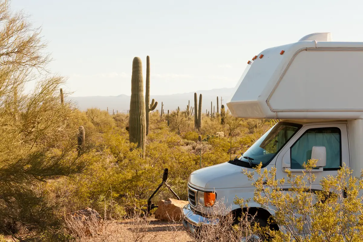
16 Tucson Boondocking Locations: If you’re thinking about boondocking near Tucson, you’ve got some solid choices. The best spots for free camping cluster around the Tucson Mountain District, the Rincon Mountains, and the Santa Rita Mountains—places where you can park without hookups and just soak up the desert vibe. These areas give you privacy and easy access to nature, but you’re still close enough to the city if you want to pop in.
Most camping here is dry and on public land, so you’ll need to show up prepared—bring water, all your supplies, and a plan for your trash and waste. People who camp out here seem to love the quiet and those wide-open skies. Whether you’re rolling through or hanging out while you look for a place to live, it’s a nice break from crowded campgrounds.
Description And Information About This Location
Want to boondock near Tucson? You’ve got options. One spot folks mention a lot is the Snyder Hill BLM area. It’s not huge, but it’s easy to get to—right near Highway 86 and South San Joaquin Road. It’s simple, just desert, but that’s kind of the point.
Another good pick is the Gilbert Ray Campground, which sits closer to the Tucson Mountain District. You get a few basic amenities, but it still feels wild enough. It’s a good balance between convenience and getting away from it all.
Tucson’s outskirts are packed with classic desert views. If you camp near Coyote and Sunset, you’ll catch some gorgeous evenings. Think saguaro cacti, big skies, and usually not many neighbors.
Most of these sites sit on BLM land, so you won’t find hookups or much in the way of facilities. Bring what you need and don’t expect much infrastructure.
| Location | Features | Access | Notes |
|---|---|---|---|
| Snyder Hill | Small, quiet BLM area | Off Hwy 86 & San Joaquin Rd | Easy to reach, no services |
| Gilbert Ray Camp | Basic amenities, close to Tucson Mt District | Accessible by car | Near some developed campsites |
| Coyote & Sunset | Scenic desert views | Various access points | Best at sunset or sunrise |
You’ll want to prep for dry conditions and haul in plenty of water and supplies. These spots give you that desert camping experience—no fees, no crowds, just you and the landscape.
Location And Access
Tucson’s got a handful of boondocking spots scattered around the city, all dry camping, no hookups. Most of them are on BLM land or in the national forests.
Head west and you’ll hit the Tucson Mountain District, which has a bunch of dispersed campsites not far from Saguaro National Park. The terrain’s classic desert—lots of views—and you can get in on dirt roads that are usually pretty manageable.
On the east side, near the Rincon Mountains, there aren’t quite as many sites, but it’s quieter and you get those mountain backdrops.
Snyder Hill BLM is a favorite, right off Highway 86 and South San Joaquin Road. It’s easy for most vehicles, with flat roads, though sometimes the sand gets a little deep.
When you’re planning, pay attention to road conditions. After a good rain, some roads get rough, so a high-clearance vehicle helps. Definitely check your maps or use an app before you head out.
Quick breakdown:
| Location | Access Type | Notes |
|---|---|---|
| Tucson Mountain Dist. | Dirt roads, public | Close to Saguaro NP, many sites |
| Rincon Mountain Area | Dirt roads | Fewer sites, quiet |
| Snyder Hill BLM | Easy access, flat | Off Hwy 86 and S. San Joaquin |
No services out here—bring your own water, food, and fuel. Cell service is hit or miss.
Directions: How To Get There And What To Expect
To reach Tucson boondocking spots, you’ll mostly use highways like Interstate 10 or Highway 89A. A lot of free campsites sit just a short drive from the city, often tucked near natural landmarks like the Rincon Mountain District or out in the desert east of town.
For instance, the “Main Drag” dispersed area sits off Highway 89A between Sedona and Cottonwood. It’s a popular stop for Arizona road trips and pretty simple to find.
Most boondocking sites require you to drive on unpaved roads. Make sure your vehicle can handle dirt or gravel—some spots don’t have clear signs, so GPS or offline maps really help.
When you pull in, don’t expect hookups, water, or bathrooms. You’ll need to pack out all your trash and bring your own water. Free camping means no fees, but you’re trading convenience for solitude.
Here’s what you’re getting into:
- Road type: Mostly dirt or gravel
- Facilities: None or very limited
- Cell service: Sometimes good, sometimes not
- Rules: Stick to Leave No Trace, camp only where allowed
- Best time to go: Cooler months—summer gets brutal
If you keep these things in mind, your Tucson boondocking trip will go a lot smoother.
Amenities And Activities
Don’t expect much in the way of amenities when boondocking near Tucson. Most dispersed camping areas don’t have toilets, running water, or electricity. Bring plenty of water and supplies—you’ll need them.
If you’re craving a few comforts, check out campgrounds like KOA. They’ve got picnic tables, bathrooms, and sometimes electric hookups. Not exactly roughing it, but handy if you want to explore Tucson without giving up all your creature comforts.
Near Saguaro National Park, you won’t see many formal campgrounds, but there’s loads of hiking, wildlife watching, and those iconic desert views. If you love saguaro cacti and open space, it’s hard to beat.
If you want something more structured, the Arizona-Sonora Desert Museum is nearby. It’s part zoo, part botanical garden, part museum—a cool way to learn about the desert and its critters.
Typical things to do around Tucson boondocking sites:
- Hiking and mountain biking
- Wildlife spotting and photography
- Stargazing (the skies are unreal out here)
- Exploring state parks and forests nearby
Cell service can be spotty, so plan ahead and don’t count on streaming Netflix from your tent.
Camping Regulations And Restrictions
When you boondock near Tucson, you’ve got to follow some rules to keep the land safe and open for everyone. Most camping areas fall under BLM or Coronado National Forest management.
Dispersed camping is usually allowed on public lands, but you’ll run into stay limits. For example, you can camp up to 14 days in a 60-day window at places like Coronado National Forest. After that, you need to move at least 25 miles away.
Don’t camp in protected zones or too close to water. Always check for local signs and maps before setting up. Fire restrictions change with the seasons, so double-check before lighting up.
Try to use established spots. There’s no guaranteed site, so it’s first come, first served. Pack out your trash and leave no trace.
Quick summary:
| Rule | Detail |
|---|---|
| Maximum stay | 14 days per 60 days |
| Distance before return | 25 miles after stay limit |
| Camping areas | Public BLM land and National Forest |
| Fires | Only if allowed, check current restrictions |
| Trash | Pack out all trash |
Check official sites for the latest updates before you hit the road.
Leave No Trace
Boondocking near Tucson means you need to follow Leave No Trace principles—it’s just part of the deal if you want the desert to stay wild for everyone else. Plan ahead and try not to mess up the plants or disturb wildlife.
Pack out every bit of trash and leftover food. Don’t bury or burn it. If you brought it in, take it home.
Stick to established roads and campsites if you can. Don’t drive or park on plants; it just tears up the soil and wrecks native vegetation.
Handle human waste properly. If there’s a toilet, use it. Otherwise, dig a hole 6-8 inches deep and at least 200 feet from water.
Go easy on campfires. Use a stove for cooking. If you really need a fire, stick to existing rings and keep it small. Make sure it’s out cold before you leave.
Watch wildlife from a distance—don’t feed them or let your pets chase them.
Respect other campers. Keep things quiet and give people space.
| Leave No Trace Rules | What You Should Do |
|---|---|
| Plan and prepare | Know regulations and bring necessary gear |
| Travel and camp on durable surfaces | Stay on roads and established campsites |
| Dispose of waste properly | Pack out trash, use toilets or dig catholes |
| Leave what you find | Don’t take plants, rocks, or artifacts |
| Minimize campfire impact | Use stoves, small fires, existing rings |
| Respect wildlife | Watch from afar, don’t feed animals |
| Be considerate of others | Keep noise down and camp apart |
Helpful Information Links
Bureau of Land Management
Recreation.Gov
National Park Service
Arizona Park Service
Arizona Trust
Arizona Fish and Game
Over 10,000 Free Boondocking Locations
Boondocking Recipes for 1000’s Of Camping Meals

Tucson Boondocking Locations
Free Boondocking Sites
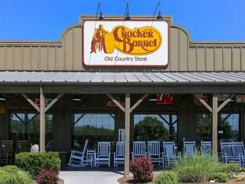
Cracker Barrel Marana
32.35972, -111.09272
Situated near the town of Marana, Arizona, the Cracker Barrel Marana boondocking site is located just off Interstate 10, offering convenient access for travelers and campers seeking a quick stopover in a desert environment. The area is primarily flat with typical Sonoran Desert vegetation including creosote bushes, cacti, and sparse trees. This spot is favored by campers who want easy access to local amenities while staying in a quiet, undeveloped setting.
The site does not offer any developed facilities such as water, restrooms, or electrical hookups, so visitors must be self-sufficient. It provides an opportunity for free overnight camping with minimal disturbance and easy access to nearby Marana conveniences, including grocery stores, fuel stations, and restaurants.
Things to Do:
Outdoor activities nearby include hiking and wildlife viewing in the Tortolita Mountains to the north, where several trails offer scenic views of the desert landscape. Marana has golf courses and several parks, providing additional recreation options. The nearby town of Tucson, about 20 miles south, offers museums, cultural sites, and urban parks. The area is also known for birdwatching due to the variety of desert birds found locally.
Directions:
From Tucson, take Interstate 10 west toward Phoenix. Exit at Marana Road (Exit 240). From the exit, head south and find local access roads near the Cracker Barrel restaurant where boondocking spots can be found nearby.
Vehicle Access:
The area is accessible via paved and gravel roads suitable for passenger vehicles, trucks, and smaller RVs. Larger trailers may find limited space for maneuvering. The terrain is flat and generally accessible year-round, though weather can occasionally affect dirt access roads.

Ironwood Forest NM 1
32.45514, -111.45866
Located in the Ironwood Forest National Monument west of Tucson, this boondocking site offers dispersed camping in a desert mountain environment dominated by ironwood trees and other desert flora. The site features rugged terrain with some elevated viewpoints and is popular among campers seeking solitude and natural desert landscapes.
There are no developed amenities; campers must be fully self-reliant. The area is managed by the Bureau of Land Management, allowing free dispersed camping with no fees, but visitors should observe Leave No Trace principles. This location attracts campers interested in wildlife viewing, including desert bighorn sheep and numerous bird species.
Things to Do:
Outdoor activities include hiking, mountain biking, and wildlife observation. Several trails within the monument provide access to desert canyons and washes. The area is known for its wildflowers during spring and rich desert fauna. Nearby towns like Marana offer essential services. The monument’s proximity to Tucson allows for day trips into the city.
Directions:
From Tucson, take Interstate 10 west toward Phoenix. Exit at Avra Valley Road and head south. Access dirt roads lead into the dispersed camping areas inside the Ironwood Forest National Monument. GPS coordinates assist in pinpointing exact locations.
Vehicle Access:
Access roads are primarily gravel and dirt, suitable for trucks and high-clearance vehicles. Passenger cars can access some areas but may struggle in rougher terrain. Large trailers are generally not recommended due to narrow and uneven roads. Access is typically year-round but can be limited by weather conditions.

Ironwood Forest NM 2
32.44358, -111.37506
Also located within Ironwood Forest National Monument, this second dispersed camping area offers a similar desert mountain environment characterized by ironwood trees, palo verde, and mesquite. The terrain varies from flat spots to rocky outcrops and small washes, providing diverse camping settings in a quiet, undeveloped environment.
There are no services, and the area is designated for dispersed camping only. Campers must bring their own water and supplies and pack out all trash. The location is chosen by those seeking solitude and natural desert scenery with excellent opportunities for stargazing due to minimal light pollution.
Things to Do:
Hiking and wildlife viewing are the primary activities. Visitors often explore nearby trails that pass through desert washes and rugged terrain. The monument is home to desert bighorn sheep, javelina, and a variety of birds such as cactus wrens and hawks. The town of Marana is the closest urban center for supplies and amenities.
Directions:
From Tucson, take Interstate 10 west. Exit at Picture Rocks Road and head south on dirt roads into the monument. GPS coordinates are used to locate specific boondocking spots within the monument.
Vehicle Access:
The roads leading to this site are gravel and dirt, best suited for trucks and vehicles with good ground clearance. Passenger cars can access some areas but may face difficulties in rougher patches. Larger RVs and trailers are not advised due to narrow and uneven access roads.

West Manville Road BLM
32.293854, -111.35112
Situated along West Manville Road on Bureau of Land Management (BLM) land west of Tucson, this boondocking site offers dispersed camping in a desert environment with flat terrain and typical Sonoran Desert vegetation. This area appeals to campers looking for free, quiet camping with easy access from Tucson.
The site has no developed facilities or services. Campers should arrive prepared with water, food, and waste disposal supplies. The area offers open skies and low light pollution, making it favorable for stargazing. The site is well-suited for campers wanting a remote desert experience near a major city.
Things to Do:
Outdoor activities include hiking in nearby desert areas and exploring the natural landscape of the Tucson Mountains. Birdwatching and photography are popular. The nearby town of Tucson provides amenities, museums, and parks. The Arizona-Sonora Desert Museum is also within driving distance for visitors interested in regional flora and fauna.
Directions:
From Tucson, take Interstate 10 west. Exit at Manville Road (Exit 250). Head south on Manville Road until reaching West Manville Road. Dispersed camping areas are found along this route on BLM-managed land.
Vehicle Access:
Roads are mostly gravel and dirt but maintained enough for passenger vehicles, trucks, and smaller RVs. Larger trailers may have difficulty navigating due to narrow sections and rough spots. The road remains accessible year-round except during heavy rain.

Snyder Hill BLM
32.156941, -111.116493
Snyder Hill is a boondocking site located on BLM land near Vail, Arizona, offering dispersed camping in a desert landscape with gentle hills and typical Sonoran Desert vegetation including mesquite, creosote, and cacti. This area is preferred by campers seeking quiet and natural surroundings with no developed facilities.
The site provides free camping without amenities, requiring visitors to be fully self-sufficient. There is no water or trash service, and fire restrictions may apply. Snyder Hill offers a quiet, undeveloped camping experience with expansive views of the desert and surrounding hills.
Things to Do:
The area supports hiking and wildlife viewing with opportunities to spot desert mammals, reptiles, and various bird species. It is located near multiple trailheads and close to the town of Vail for provisioning. The nearby Colossal Cave Mountain Park and other outdoor destinations are accessible for day trips.
Directions:
From Tucson, take Interstate 10 east toward New Mexico. Exit at Vail Road (Exit 299). Head south and then east on local dirt roads toward Snyder Hill. GPS coordinates help identify specific camping spots.
Vehicle Access:
Roads are gravel and dirt, accessible to trucks and passenger vehicles. Some areas may be rough for standard passenger cars, and larger trailers are not recommended due to narrow, uneven roads. Weather may impact accessibility during rains.

Bigelow Road
32.413776, -110.720987
Situated within the Coronado National Forest in the Santa Catalina Mountains, Bigelow Road offers a dispersed boondocking experience characterized by forested terrain at an elevation of approximately 7,000 feet. This area is accessible via Mount Bigelow Road, which winds through dense pine and oak woodlands. The site provides a remote, quiet setting for campers who prefer solitude and cooler temperatures compared to lower desert elevations.
The boondocking spots along Bigelow Road are primitive, without developed amenities such as water, restrooms, or electrical hookups. Campers rely on self-contained rigs or tents and must pack in all supplies, including water and waste disposal materials. The high elevation often results in significantly cooler temperatures than Tucson below, especially at night, making it a popular summer refuge for those escaping the heat of the desert.
Things to Do:
Outdoor enthusiasts visiting Bigelow Road can engage in a variety of activities nearby. Hiking is popular with several trailheads in close proximity, including the nearby Incinerator Ridge Trail and trails leading to Mount Lemmon, the highest peak in the Santa Catalina range. These trails offer opportunities to view wildlife such as deer, birds, and occasionally black bears. Photography and birdwatching are common as well due to the diverse plant and animal life supported by the forest ecosystem. Stargazing is excellent here because of the site’s remote location away from urban light pollution. Additionally, the nearby town of Summerhaven provides access to small shops and restaurants.
Directions:
From Tucson, take the Catalina Highway (General Hitchcock Highway) northeast for about 20 miles toward Mount Lemmon. After passing the Palisades Visitor Center, continue until you reach the turnoff for Mount Bigelow Road on your right. Follow this gravel road for several miles; dispersed camping sites are found along this stretch. Signs for dispersed camping may be sparse, so it’s advisable to use GPS coordinates or maps.
Vehicle Access:
Mount Bigelow Road is a maintained gravel road passable by most passenger vehicles and RVs; however, larger rigs and trailers should exercise caution due to winding segments and limited turnaround areas. The road is typically open from spring through fall but may be gated in winter, usually between December 31 and March 1, due to snow. Campers should verify seasonal access ahead of time and prepare for potentially rough patches and narrow sections.

Incinerator Ridge
32.409167, -110.701334
Situated within the Coronado National Forest near the Santa Catalina Mountains, the Incinerator Ridge boondocking site offers dispersed camping in a semi-forested mountainous setting. The site is located along a gravel forest road that leads to the Incinerator Ridge Trailhead. This area is favoured by campers seeking peaceful surroundings, a moderate elevation around 6,200 feet, and close proximity to hiking and outdoor recreation.
The environment around Incinerator Ridge consists of mixed pine and oak woodlands with scenic mountain views. Dispersed camping here is primitive with no developed amenities, so campers must be fully self-sufficient, bringing water, food, and waste disposal supplies. This site is ideal for those wanting to experience nature away from developed campgrounds and urban noise.
Things to Do:
Campers at Incinerator Ridge have access to hiking and mountain biking on nearby trails, including the popular Incinerator Ridge Trail, which offers a moderately challenging route with beautiful views over the Santa Catalina range and Tucson valley below. Wildlife viewing is common, with local species including mule deer, javelina, various bird species, and occasionally bobcats. The proximity to Mount Lemmon allows for day trips to explore additional hiking trails, rock climbing areas, and the town of Summerhaven. During clear nights, the remote location offers excellent stargazing opportunities.
Directions:
From Tucson, head northeast on the Catalina Highway (General Hitchcock Highway) toward Mount Lemmon. After passing the Palisades Visitor Center, turn onto Mount Lemmon Road (Forest Road 300) and continue to the turnoff for Incinerator Ridge Road (Forest Road 38). Follow this well-maintained gravel road for several miles until reaching the dispersed camping spots near the trailhead.
Vehicle Access:
The roads to Incinerator Ridge are mostly gravel but well maintained, suitable for passenger vehicles and smaller RVs. Larger trailers may find maneuvering difficult on narrower or winding sections. Seasonal closures or restrictions may apply in winter months due to snow, so checking road status before traveling is recommended. The primitive nature of the site requires campers to be prepared for limited or no services.

E Redington Road
32.261879, -110.649788
Situated along East Redington Road within the Coronado National Forest near the Santa Catalina Mountains, this boondocking area offers dispersed camping amid a semi-arid woodland environment at approximately 4,200 feet elevation. The site features wide open spaces with scattered trees, primarily oaks and mesquites, set against a backdrop of rugged hills and desert terrain. This location is popular among campers looking for quiet, off-grid camping close to Tucson but away from the city’s bustle.
Dispersed camping along E Redington Road is primitive with no designated facilities, water, or restrooms. Campers must bring all necessary supplies and pack out all waste. The area’s elevation and vegetation provide a somewhat cooler environment compared to the desert floor. Fire restrictions may apply depending on the season and local regulations.
Things to Do:
Outdoor activities include hiking, mountain biking, and wildlife watching. The nearby Redington Pass offers multiple trailheads that lead into the Santa Catalina Mountains, with access to hiking routes that vary from easy walks to more strenuous climbs. Birdwatchers can spot species native to the region, including various raptors and songbirds. The proximity to the town of Tucson allows for day trips to urban amenities, while still enjoying the natural environment. Photographers often visit for sunrise and sunset views of the surrounding mountains and desert landscape.
Directions:
From Tucson, take the Speedway Boulevard east until it transitions into East Redington Road. Follow E Redington Road approximately 10 miles into the Coronado National Forest. Dispersed camping spots can be found along this stretch, especially near forks and pullouts. GPS coordinates can assist in locating specific camping areas.
Vehicle Access:
The road is paved initially but quickly turns to gravel and dirt, suitable for most passenger vehicles and smaller RVs. Larger trailers may find some narrow sections and uneven road surfaces challenging. The area is generally accessible year-round, though wet weather may impact road conditions temporarily. Campers should prepare for no services and be self-reliant.

Muleshoe Ranch
32.33786, -110.238687
Situated near the Muleshoe Ranch Wildlife Area, east of the Santa Catalina Mountains in Arizona, this boondocking location offers dispersed camping on relatively flat desert terrain with views of surrounding grasslands, rocky outcrops, and mountain ranges. The site lies within a semi-arid environment characterized by desert shrubs, mesquite trees, and occasional cactus. Campers favor this spot for its open spaces, wildlife observation opportunities, and quiet atmosphere away from developed campgrounds.
Muleshoe Ranch is a popular area for hunters during the designated seasons due to its proximity to a large wildlife management area. However, outside hunting seasons, the location provides peaceful camping with few visitors. The site offers no amenities—no water, restrooms, or electrical hookups—so campers must be fully prepared and self-sufficient. This makes it suited for those experienced with primitive camping and off-grid setups.
Things to Do:
Visitors can enjoy hiking, birdwatching, and wildlife observation, as the nearby Muleshoe Ranch Wildlife Area is home to mule deer, javelina, coyotes, and many bird species including hawks and quail. The area’s open landscape offers excellent opportunities for photography and nature study. Additionally, the nearby town of Oracle provides access to groceries, fuel, and other services. Oracle State Park is also close by, offering maintained trails and picnic areas. Stargazing is excellent here due to minimal light pollution.
Directions:
From Tucson, head north on Oracle Road (State Route 77) toward the town of Oracle. After approximately 30 miles, turn east onto Empirita Road (a gravel road) and continue to the Muleshoe Ranch area. Dispersed camping spots can be found along this route and nearby side roads. GPS coordinates are useful for pinpointing specific campsites.
Vehicle Access:
Roads leading to Muleshoe Ranch are mostly well-maintained gravel roads suitable for passenger vehicles, trucks, and smaller RVs. Larger trailers may have difficulty on some narrower or uneven sections. The terrain is generally flat with few obstacles, making it accessible year-round except during severe weather. Campers should be ready for a lack of services and facilities.

Empirita Road
31.97814, -110.50993
Situated along Empirita Road near Vail, Arizona, this dispersed camping area provides a desert boondocking experience within the Sonoran Desert region. The site features flat to gently rolling terrain with typical desert vegetation such as creosote bushes, mesquite trees, and various cacti species. The area is popular with campers seeking a quiet, off-grid experience within a reasonable driving distance from Tucson and the town of Vail.
Dispersed camping along Empirita Road is primitive, with no amenities like water, restrooms, or trash disposal. Campers need to bring all necessary supplies and adhere to Leave No Trace principles. The site’s relatively low elevation results in hot summers but milder winter conditions compared to higher mountain camping spots. Fire restrictions are often in place during dry months.
Things to Do:
Outdoor recreation near Empirita Road includes hiking, birdwatching, and off-road vehicle use on designated routes. The nearby Coronado National Forest provides trailheads for desert hiking, and the Rincon Mountains are accessible for more rugged terrain exploration. Bird species commonly observed include roadrunners, hawks, and quail. Photography enthusiasts often visit for desert landscapes and wildlife shots. The proximity to Vail and Tucson allows for convenient resupply and access to local amenities.
Directions:
From Tucson, take Interstate 10 east toward Vail. Take exit 297 for Vail Road and head south on Vail Road. Turn east onto Empirita Road (gravel/dirt road). Continue along Empirita Road for several miles where dispersed camping areas are found. Using GPS coordinates helps in locating suitable spots.
Vehicle Access:
Empirita Road is primarily a gravel and dirt road maintained for general vehicle access. It is passable by passenger vehicles, trucks, and smaller RVs, though larger trailers should use caution due to uneven surfaces and narrow sections. The road is accessible year-round but can be affected by heavy rains. No services are available at the site.
Arizona Trust Permit Sites

Golder Ranch Road
32.482084, -110.886479
Golder Ranch Road is a dispersed camping site located northeast of Tucson, Arizona, on Bureau of Land Management (BLM) land. The area offers a desert camping experience with typical Sonoran Desert vegetation, including creosote bush, palo verde trees, and various cacti. The terrain is generally flat to gently rolling, providing ample space for tents, trucks, and smaller RVs.
There are no developed facilities at this site—no water, restrooms, or electrical hookups—so campers must come prepared with their own supplies and pack out all waste. The site is free to use, with no fees, and is popular with those seeking a quiet, natural setting within reasonable proximity to Tucson.
Things to Do:
Camping here provides opportunities for hiking and wildlife observation, including spotting desert animals such as jackrabbits, coyotes, and various bird species. Nearby recreational areas include the Catalina State Park to the east, which offers more developed trails and picnic areas. The proximity to Tucson (about 20 miles away) means visitors can easily access urban amenities when needed. Stargazing is excellent due to low light pollution.
Directions:
From Tucson, take Interstate 10 north toward Phoenix. Exit at Golder Ranch Road (Exit 264) and head east. The dispersed camping areas can be found along the dirt and gravel roads branching off Golder Ranch Road. GPS coordinates help campers pinpoint specific spots.
Vehicle Access:
Access roads are mostly dirt and gravel, suitable for trucks and passenger vehicles. The terrain is generally manageable for most vehicles, but larger RVs or trailers may face difficulties with narrow roads and limited turning space. The site is accessible year-round, though heavy rains may temporarily affect road conditions.

Marana Tangerine Road
32.43399, -111.123063
The Marana Tangerine Road campground is a BLM-managed dispersed camping area located northwest of Tucson, near the town of Marana, Arizona. This site is characterized by flat desert terrain with abundant creosote bushes, mesquite trees, and saguaro cacti typical of the Sonoran Desert. It offers free camping with no developed amenities, so visitors must be fully self-sufficient.
This location is well-suited for travelers seeking a quiet, natural environment close to Tucson while avoiding crowded campgrounds. It is also used by transient RVers and campers who prefer dispersed camping over commercial campgrounds.
Things to Do:
Visitors can enjoy outdoor activities such as hiking, photography, and birdwatching. The nearby Tortolita Mountains provide opportunities for more extensive hiking and exploration. The area is rich in desert wildlife including javelinas, rabbits, and a variety of desert birds. The nearby town of Marana provides essential services, including groceries, fuel, and restaurants.
Directions:
From Tucson, take Interstate 10 west. Exit at Tangerine Road (Exit 249). Head north on Tangerine Road, and dispersed camping areas can be found on BLM land adjacent to the road. GPS coordinates assist in locating specific camping spots.
Vehicle Access:
Access is via gravel and dirt roads accessible by passenger vehicles, trucks, and smaller RVs. Larger trailers might find it challenging to navigate due to road width and surface conditions. The site is generally accessible year-round, though road conditions may vary after heavy rain.

Mescal Road
32.011853, -110.428905
Situated along Mescal Road east of Vail, Arizona, this dispersed camping area offers boondocking in a desert environment characteristic of the Sonoran Desert region. The site features flat to gently rolling terrain with desert vegetation such as mesquite, creosote, and various cacti. This location is favored by campers seeking quiet, undeveloped camping with proximity to Tucson and easy highway access.
Mescal Road provides a remote setting with no developed facilities, so campers must be fully self-sufficient. There are no water sources, restrooms, or trash disposal on-site, and fire restrictions may apply seasonally. The area offers open skies and minimal light pollution, making it suitable for stargazing.
Things to Do:
Outdoor activities include hiking, birdwatching, and exploring nearby trails within the Coronado National Forest. The Rincon Mountains, accessible from nearby trailheads, provide more challenging hikes and cooler mountain air. Wildlife commonly observed includes javelina, mule deer, and various desert birds such as roadrunners and hawks. The area is popular for photography of desert landscapes and wildlife. The town of Vail and Tucson offer nearby services including groceries, fuel, and dining.
Directions:
From Tucson, take Interstate 10 east toward Vail. Exit at Vail Road (Exit 297) and head south. Turn east onto Mescal Road, a gravel road where dispersed camping sites are found along the way. GPS coordinates assist in locating suitable spots.
Vehicle Access:
Mescal Road is primarily a gravel road accessible to passenger vehicles, trucks, and smaller RVs. Larger trailers may find some sections narrow or uneven. The road is generally accessible year-round but can be impacted by weather. No amenities or services are available, so campers should prepare accordingly.

Via Ranch Del Cielo
32.077793, -110.633864
Located along East Via Rancho Del Cielo near the Catalina Foothills east of Tucson, this boondocking area offers dispersed camping in a desert and semi-arid environment. The terrain is primarily flat with desert scrub, mesquite trees, and distant views of the Santa Catalina Mountains. This location appeals to campers looking for solitude close to Tucson with easy access to outdoor activities.
This site is undeveloped, providing no amenities such as water, restrooms, or trash disposal. Campers must be self-reliant and adhere to fire restrictions during dry seasons. The area’s elevation is moderate, providing warm to hot conditions in summer and mild winters.
Things to Do:
Nearby recreational opportunities include hiking in the Santa Catalina Mountains via multiple trailheads a short drive away. The Catalina State Park is accessible for day trips, featuring maintained trails and picnic areas. Wildlife viewing is common, including sightings of desert mammals, reptiles, and birds. The Tucson metropolitan area is within reach for supplies and additional amenities. Photographers visit to capture desert sunsets and mountain landscapes.
Directions:
From Tucson, head east on Tanque Verde Road. Turn north onto Camino de Oeste and then east onto Via Rancho Del Cielo. Dispersed camping spots are located along this road. GPS coordinates help identify specific sites.
Vehicle Access:
Roads are primarily gravel and dirt, suitable for passenger vehicles, trucks, and smaller RVs. Larger trailers may find some sections narrow or rough. The road is typically accessible year-round except during extreme weather events. No developed facilities are present.
Paid Campgrounds

Molino Basin
32.337118, -110.693169
Molino Basin Campground is located within the Coronado National Forest near the Santa Catalina Mountains northeast of Tucson. This developed campground offers forest camping at an elevation around 6,000 feet, surrounded by pine and oak woodlands. It provides a more structured camping experience compared to dispersed sites, featuring amenities such as vault toilets, picnic tables, and fire rings.
The campground is favored by visitors seeking forest scenery, cooler temperatures during summer, and proximity to hiking trails. There is no potable water available, so campers must bring their own. The site allows reservations or first-come, first-served stays, with a nightly fee typically around $15 per night.
Things to Do:
Molino Basin serves as a base for hiking the nearby Bear Canyon Trail and Seven Falls Trail, popular routes within the Santa Catalina Mountains offering waterfalls, scenic vistas, and wildlife viewing. Birdwatchers frequent the area for sightings of various forest bird species. The nearby town of Summerhaven provides access to restaurants and shops. Winter visitors can enjoy cooler weather and occasional snow.
Directions:
From Tucson, take the Catalina Highway (General Hitchcock Highway) northeast toward Mount Lemmon. Turn onto Molino Basin Road (Forest Road 38). The campground is well-marked and located a short distance from the main road.
Vehicle Access:
Access roads are paved or well-maintained gravel suitable for passenger vehicles, trucks, and most RVs. Large trailers should verify road width and turning radius before attempting access. The campground is generally open year-round, though winter weather can occasionally cause temporary closures.

Colossal Cave
32.058151, -110.632371
Colossal Cave Mountain Park Campground is situated near Vail, Arizona, offering a developed camping experience with amenities including water, restrooms, picnic tables, and fire rings. The campground lies in a desert foothill setting at approximately 3,800 feet elevation with views of rugged limestone cliffs and the surrounding desert landscape.
The park is well known for the Colossal Cave, a large limestone cave system offering guided tours, and the campground serves as convenient lodging for visitors. Campground fees are approximately $15–$20 per night, with reservations recommended during peak seasons.
Things to Do:
The primary attraction is the Colossal Cave, featuring guided tours exploring its extensive cave passages and geological formations. Hiking trails surround the campground, including the Romero Ruins Trail and other routes showcasing desert flora and fauna. Horseback riding and picnicking are also popular. The park hosts seasonal events and educational programs.
Directions:
From Tucson, take Interstate 10 east to Exit 281 for Colossal Cave Road. Head south on Colossal Cave Road for about 6 miles. The park entrance and campground are clearly marked.
Vehicle Access:
The access road is paved and suitable for all vehicle types, including large RVs and trailers. The campground provides parking spaces adequate for various sizes of recreational vehicles. The facility is open year-round, with no seasonal closures.
Frequently Asked Questions
You’ll find boondocking spots on public land and around smaller towns near Tucson. There’s everything from free dispersed sites to places with a few basic amenities. Knowing the rules and where it’s legal makes planning way easier.
What are some popular areas for boondocking around Tucson?
Some favorite spots are BLM lands just outside Tucson, especially around the Tucson Mountains. You’ll also hear about Indian Bread Rocks and the Kofa National Wildlife Range—quiet, scenic, and a little out of the way.
Where can I find a map of dispersed camping areas near Tucson?
Check the official BLM website or hop on Reddit’s r/vandwellers community. You’ll find maps that show public lands where you can camp near Tucson.
Are there any free camping options within close proximity to Tucson?
Yep, you can camp for free on BLM land close to the city. Some Walmarts allow overnight parking, but always ask the store manager before settling in.
What are the regulations for boondocking on BLM land in Arizona?
On BLM land, you can usually stay up to 14 days in a 28-day period. Stay at least 200 feet from water and pack out your trash. Check for local rules—some spots have quirks.
How can you locate legal places for boondocking in Arizona during winter?
Winter boondocking is big in places like Quartzsite. Look up updated BLM maps or check local forums for seasonal info. The best spots fill up quickly, so plan ahead if you want a good one.
Can I legally camp on the side of the road while traveling through Arizona?
Arizona doesn’t let you camp on most highways or state roads. Sometimes you’ll find a spot on quiet county roads or at a rest area, but you’ve really got to check local rules first unless you want to risk a fine. Pulling off onto the shoulder of a busy road? Not only is that risky, it’s usually against the law.