


11 Tuzigoot National Monument Boondocking Locations: Looking to camp near Tuzigoot National Monument without shelling out for a campsite? You’ve got some boondocking options. Some of the best spots are scattered around nearby public lands, with a handful of free camping areas close to Camp Verde and Cottonwood. These places let you park your RV or pitch your tent in a peaceful, natural setting.
You won’t find official boondocking inside the monument, but the nearby state parks and BLM land give you a shot at staying off-grid while you check out those ancient pueblo ruins. If you figure out where to look and stick to the rules, you’ll probably have a comfortable, safe trip.
It’s a pretty good deal: you get the history and views of Tuzigoot, and you don’t have to cough up extra cash for camping. When you plan your stay, look at both free campsites and some of the affordable ones near Tuzigoot National Monument. For more on where to park and how to get in, guides like this one about Tuzigoot National Monument camping can help.
Description And Information About This Location
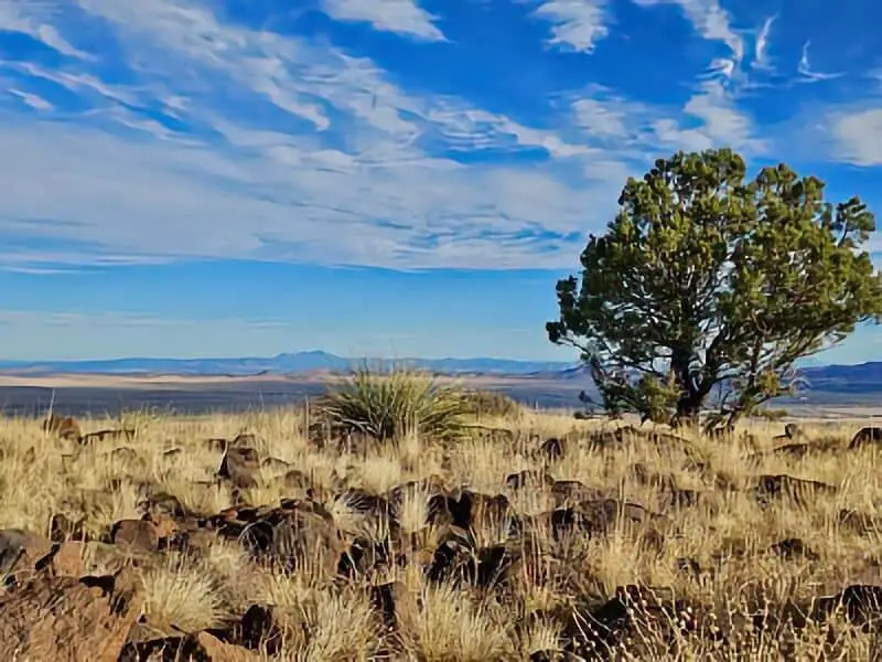
Tuzigoot National Monument protects an ancient pueblo built by the Sinagua people over a millennium ago. The site sits on a small hill, about 120 feet above the Verde River floodplain. You can wander through the ruins of a 110-room village, including some second and third-story dwellings tucked into the cliffs.
You’ll find Tuzigoot near Clarkdale, Arizona, roughly 65 miles south of Flagstaff. The surroundings are pure high-desert—quiet, open, and a little wild. Boondocking here means you’ll need to be self-reliant, since there aren’t any hookups or services.
The stone walls sit atop limestone and sandstone ridges, and the elevation gives you some pretty sweeping views of the Verde Valley. If you want a mix of cultural history and outdoor time, this spot delivers.
If you’re camping near Tuzigoot, respect the environment and any posted rules. Stay back from the ruins and don’t mess with the site—let’s keep it around for the next folks.
Key facts about Tuzigoot National Monument:
- Built by the Sinagua culture
- 110-room pueblo with multi-story cliff dwellings
- Located on a limestone and sandstone ridge
- About 120 feet above the Verde River floodplain
- 65 miles south of Flagstaff, Arizona
You can dig up more info at the NPS Tuzigoot page.
Location And Access
Tuzigoot National Monument sits in central Arizona, not far from Cottonwood and Jerome. It’s perched on a hill above the Verde Valley, so if you’re coming from Sedona (just 20 miles away), it’s an easy detour. This spot works well if you’re already exploring Oak Creek Canyon or wandering through the area.
To get there, take Historic Highway 89A west from Cottonwood. The signs are pretty clear, so you shouldn’t have trouble finding it. Coming from Jerome? Just head south on 89A toward Cottonwood, then go a bit east.
You’ll need to look outside the monument itself for boondocking, since Tuzigoot doesn’t offer camping. Dead Horse Ranch State Park and some other free or low-cost sites near Cottonwood are your best bets. You can find camping spots with basic access off main roads, often tucked among oak and mesquite.
Watch out for the roads close to the monument—they’re mostly paved, but a few stretches get narrow. Regular cars and small RVs handle it fine. If you want to hike into your campsite or bring a tent, look for spots near Oak Creek or along the dirt forest routes.
For more on boondocking near Tuzigoot, check camping maps at Free Campsites Near Tuzigoot or see Recreation.gov for site rules and any updates.
Directions: How To Get There And What To Expect
Start out on Interstate 17 (I-17) and take exit 287 for Highway 260 West toward Cottonwood.
At the junction with Highway 89A, turn left and drive through Cottonwood. The monument’s a short drive from there.
If you’re coming from Sedona, just follow Highway 89A west for about 17 miles. Before you hit Cottonwood, turn right onto E Mingus Avenue and you’ll be close.
The area’s accessible for RVs and camping vehicles, but don’t expect fancy amenities—boondocking near Tuzigoot is all about the basics and the quiet.
Inside the monument, you can walk a short self-guided loop trail (about a third of a mile) that winds through the ancient pueblo. It’s a cluster of rooms built nearly a thousand years ago.
| Step | Directions |
|---|---|
| 1 | Take I-17 exit 287 to Highway 260 W |
| 2 | Turn left on Highway 89A at Cottonwood |
| 3 (from Sedona) | Take Highway 89A west for 17 miles |
| 4 (from Sedona) | Turn right on E Mingus Avenue |
You’ll find a quiet place with historical ruins and big views. There aren’t any large visitor centers or stores nearby, so bring what you need.
If you want more driving tips, check the Directions page.
Amenities And Activities
When you camp near Tuzigoot, you’ll find just the basics to keep you comfortable. Some campgrounds like Dead Horse Ranch State Park have drinking water, hookups, picnic tables, and real bathrooms with showers. Not exactly roughing it, but still feels like camping.
If you’re into history, don’t skip the on-site museum—it’s got ceramics, textiles, and tools they found during digs. There’s something cool about seeing the real stuff up close.
Fishing’s an option too, especially at Dead Horse Ranch State Park. The lakes there are stocked with trout and bass, so you can kick back and cast a line after you set up camp.
Sunsets at Tuzigoot? They can be pretty impressive. The colors over the desert landscape are worth sticking around for. Bring your camera, or just soak it in.
If you want a little more culture, check out the local galleries or art museums around Tuzigoot. There’s a lot of Southwest art in the area.
Prefer boondocking? Free and cheap camping spots are scattered around the monument. They don’t have many amenities, but you’ll get a quieter, more natural camp experience.
You can find more about camping and what to do at Tuzigoot National Monument here.
Camping Regulations And Restrictions
If you’re camping near Tuzigoot, you’ll need to stick to some rules to keep the place protected and safe. Dispersed camping is only allowed up to 300 feet from the road and you have to be at least one mile past the day-use camping area. That keeps things a little more private and less crowded.
Campfires and charcoal? Not always allowed. When fire restrictions kick in (which happens a lot), all campfires and charcoal are banned. Always check the latest fire rules before you set up.
Federal regulations (Title 36 of the Code of Federal Regulations) still apply—so pay attention to where you camp, what you do, and how you treat the land and old ruins.
Give other campers space. Pick a spot away from others and avoid setting up near trails or busy areas—everyone appreciates a little peace and quiet.
Don’t build anything permanent or dig holes. Pack out everything you bring in and try to leave the place looking like you were never there.
For the nitty-gritty details—closures, permits, or special rules—see the official Tuzigoot National Monument regulations. It’s worth a look to avoid surprises.
Leave No Trace
Camping near Tuzigoot? Stick to Leave No Trace principles so the land and history stay protected.
Pack out all your trash. Bring a bag, grab your waste (yeah, even the gross stuff), and don’t bury or burn anything.
Don’t mess with plants, rocks, or artifacts. Tuzigoot’s a protected archaeological site, so leave everything where it is.
If fires are allowed, use an existing fire ring. Keep fires small and drown them with water before you leave.
Stick to trails—don’t trample plants or make new paths.
Watch wildlife from a distance. Don’t feed or approach animals. Seriously, they’re better off wild.
If you need to use a portable toilet or dig a cathole, make sure it’s at least 200 feet from water. Cover up and disguise anything you leave behind.
Quick summary:
| Action | Why It Matters |
|---|---|
| Pack out all trash | Keeps site clean and prevents pollution |
| Don’t disturb artifacts | Preserves history and culture |
| Use designated fire rings | Reduces wildfire risk and land damage |
| Stay on trails | Protects plants and wildlife habitat |
| Respect wildlife | Maintains natural behavior and health |
If you take care of the place, Tuzigoot will stay beautiful for the next round of campers. More on camping near Tuzigoot at Tuzigoot National Monument.
Helpful Information Links
Bureau of Land Management
Recreation.Gov
National Park Service
Arizona Park Service
Arizona Trust
Arizona Fish and Game
Over 10,000 Free Boondocking Locations
Boondocking Recipes for 1000’s Of Camping Meals

Tuzigoot National Monument Boondocking Locations
Free Boondocking Locations

Boondocking SR 179 Lake Montezuma
34.683518, -111.726395
Situated off State Route 179 near Lake Montezuma, Arizona, this dispersed camping area offers a primitive setting without developed facilities. The site is located at an elevation of approximately 3,890 feet and is open year-round for tent camping. The surrounding area features trails and natural landscapes suitable for outdoor activities. Campers should be prepared for a lack of amenities and practice Leave No Trace principles to preserve the natural environment.
Things to Do:
Campers can engage in hiking along nearby trails, horseback riding, and wildlife observation. The proximity to Lake Montezuma provides opportunities for fishing and exploring the local environment. The area’s natural beauty makes it suitable for photography and nature study. The diverse flora and fauna in the region offer a rich experience for nature enthusiasts. During the fall, the changing colors of the foliage add to the scenic beauty of the area.
Directions:
From Lake Montezuma, take State Route 179 south for approximately 2 miles. Turn onto Forest Road 618 and continue for about 1 mile to reach the dispersed camping areas. Be aware that the road may have rough sections and limited turnaround spots. It’s advisable to check the current road conditions and weather forecasts before traveling.
Vehicle Access:
The access road to the camping area is rough and may be challenging for low-clearance vehicles. High-clearance vehicles are recommended, and drivers should exercise caution, especially if the area is crowded, as there are limited spots and few places to turn around. Large RVs and trailers may find access difficult due to the road conditions. Campers should ensure their vehicles are well-maintained and equipped for off-road travel.
Camping Near Cherry – Prescott Valley Boondocking
34.5418, -112.08325
This spot near the historic town of Cherry, Arizona offers free boondocking in a remote and lightly forested setting. It provides a peaceful retreat with minimal traffic and good elevation for cooler temps.
Camping Details:
Free dispersed camping with a 14-day stay limit. There are no amenities—campers must be fully self-sufficient. Suitable for tents, vans, and small RVs. Space is limited and some areas are uneven.
Road Access:
Located off Cherry Road, a mostly gravel road connecting to Highway 169. The road is passable by most vehicles, though some parts may be rough or rutted. Drive cautiously, especially after rain.
Nearby Attractions:
The historic mining town of Cherry is just minutes away. Prescott National Forest offers nearby trails and scenic areas to explore. Camp Verde and Prescott Valley are both reachable within about 45 minutes.
Reminders:
Stay on durable surfaces and avoid widening pullouts. Respect wildlife and the quiet nature of the area. Always pack out trash and greywater—there are no services nearby.

Powell Springs CG – AZ BD
34.578415, -112.068726
Powell Springs is a small, quiet campground tucked along a forested stretch of FR 104, southeast of Mingus Mountain. Nestled in the pines, the site offers a shaded escape from the desert heat at around 6,000 feet elevation.
Camping Details:
Free camping is allowed with a 14-day limit. There are a handful of formal sites with picnic tables and fire rings. No water or trash services are available, and there may not be a restroom onsite—come prepared. Ideal for tents and vans; small RVs may fit, but space is limited.
Road Access:
Accessed via FR 104 from Highway 260. The road is narrow but generally maintained for passenger vehicles. The last stretch into the campground may be rough in places—drive slowly and avoid after heavy rains.
Nearby Attractions:
Located near Mingus Mountain and Woodchute Wilderness. Scenic drives and hikes are available in the surrounding Prescott National Forest. Cottonwood and Camp Verde are both within 30–40 minutes for supplies.
Reminders:
Fire restrictions are common in this region. Use designated sites and keep noise to a minimum. Wildlife is active here—secure food and trash properly. Practice Leave No Trace at all times.

Boondocking Spiral Sedona
34.866171,-111.899810
Located on the western edge of Sedona near Boynton Pass Road, the “Boondocking Spiral” is a dispersed campsite known for its artistic spiral arrangement of rocks. It’s situated on public land within the Coconino National Forest, where dispersed camping is allowed in designated areas.
Boondocking Locations
This site offers primitive camping with no services—no restrooms, no water, and no trash collection. Campers must pack in all essentials and pack out all waste. The ground surface is packed dirt with scattered gravel, and space is limited to smaller setups such as tents, vans, or compact RVs.
Things to Do:
The location is close to Boynton Canyon, a popular hiking area, and scenic viewpoints overlooking Red Rock formations. Sedona’s trail system, including Devil’s Bridge and Fay Canyon, is within a short drive. This area is also known for spiritual tourism due to local vortex sites.
Directions:
From Sedona, head west on AZ-89A to Dry Creek Road. Take Dry Creek north, then turn left on Boynton Pass Road. The spiral is found near the junction with FR 152D. GPS: 34.866171, -111.899810.
Vehicle Access:
Most passenger vehicles can reach the site in dry conditions. However, the final road section is rough, and high-clearance is recommended. Larger RVs will not fit due to limited turnaround space.

FR 525 & 525C – Sedona Boondocking
34.833159, -111.908447
This is one of the most popular boondocking corridors near Sedona, stretching along Forest Roads 525 and 525C. It lies within the Coconino National Forest and offers large, open camping areas with expansive views of red rock formations. Dispersed camping is allowed only in designated spots marked with “Camping Permitted” signs.
Boondocking Locations
Multiple cleared campsites line both sides of FR 525 and its spur, FR 525C. Sites are dirt or gravel pull-offs with plenty of room for tents, vans, and large RVs. There are no amenities—no water, no toilets, and no trash collection. Generators are allowed, but campers must adhere to 14-day stay limits.
Things to Do:
This area is convenient for exploring Sedona’s Red Rock Scenic Byway, Palatki Heritage Site, and several hiking trails. Mountain biking and off-road vehicle use are also popular.
Directions:
From Sedona, take AZ-89A west to Forest Road 525 (also signed as Loy Butte Road). Continue north into the designated dispersed camping corridor. GPS: 34.833159, -111.908447.
Vehicle Access:
FR 525 is generally passable by most vehicles when dry. FR 525C is rougher and may require high-clearance. RVs and travel trailers use this area frequently, but sections may become muddy or rutted after rain.

Clarkdale Boondocking Campsites
34.838052, -112.049513
Located just northwest of Clarkdale, this dispersed camping zone lies within the Prescott National Forest. It provides quiet, undeveloped campsites with easy access to the Verde River, Tuzigoot National Monument, and the town of Jerome.
Boondocking Locations
The area offers several cleared pull-offs and dispersed pads suitable for tents, vans, and medium-sized RVs. There are no facilities—no water, trash service, or toilets. Sites are spread out enough to provide privacy, and the terrain consists of compacted dirt and low desert brush.
Things to Do:
Popular activities include kayaking or fishing in the Verde River, visiting Tuzigoot National Monument, or touring the historic mining town of Jerome. Hiking and wildlife viewing are also available nearby in the surrounding forest.
Directions:
From Clarkdale, take Broadway Road west and then turn north onto Tuzigoot Road. Campsites are scattered along the forest access roads branching north of the town. GPS: 34.838052, -112.049513.
Vehicle Access:
Most campsites are accessible by standard vehicles in dry conditions. Some sites further in may require high-clearance. RVs should scout ahead due to limited turnaround space and uneven terrain.
Mingus Mtn Upper FR413 – Arizona Boondocking
34.694496, -112.144356
Upper Forest Road 413 is located atop Mingus Mountain between Prescott Valley and Jerome. This high-elevation area offers cool pine forest surroundings and sweeping views into the Verde Valley. It is managed by the Prescott National Forest, where dispersed camping is permitted along established forest roads.
This location has multiple forest clearings along FR 413 for dispersed use. Sites are primitive, with no potable water, no restrooms, and no trash services. Suitable for tents, vans, and smaller RVs. Fires are allowed only when local fire restrictions permit.
Things to Do:
Nearby recreation includes hang gliding from Mingus Mountain, hiking along the Woodchute Wilderness trails, and day trips into Jerome. The area is also popular for stargazing and wildlife observation.
Directions:
From Jerome, head east on AZ-89A and take the forest road turn-off toward Mingus Mountain. Follow signs for FR 413 and continue along the upper ridge. GPS: 34.694496, -112.144356.
Vehicle Access:
The road is gravel and can be rough in spots, particularly after weather events. High-clearance vehicles are advised, and RVs over 25 feet may have trouble maneuvering. Snow is possible in winter months.

Loy Butte Road
34.865956, -111.906091
Situated along Forest Road 525 within the Coconino National Forest, approximately 10 miles southwest of Sedona, Arizona, Loy Butte Road offers designated dispersed camping opportunities amidst the region’s iconic red rock formations. The area features a rugged desert landscape with expansive views and is managed by the U.S. Forest Service. Campsites are primitive, lacking developed facilities such as drinking water, electric hookups, or restrooms. However, porta potties are available in certain areas for convenience. Campers are advised to practice Leave No Trace principles and be prepared for self-sufficient camping.
Things to Do:
The surrounding area offers numerous outdoor activities, including hiking, mountain biking, and off-roading. Nearby attractions include Red Rock State Park and the scenic trails of Coconino National Forest. The region’s diverse flora and fauna make it a popular spot for wildlife viewing and photography.
Directions:
From downtown Sedona, head west on State Route 89A for approximately 5 miles. Turn right onto Forest Road 525 (Loy Butte Road) and continue for about 6 miles. Dispersed campsites are available along this stretch.
Vehicle Access:
The initial portion of Forest Road 525 is accessible to most vehicles, including RVs and trailers. However, as you progress further, the road becomes rougher, and high-clearance vehicles are recommended. Campers should be prepared for dusty conditions and limited cell service.
Boondocking Near Montezuma Castle
34.607353, -111.851341
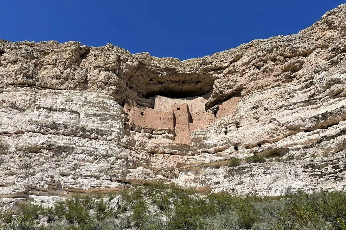
Located near Montezuma Castle National Monument in Camp Verde, Arizona, this boondocking area offers dispersed camping opportunities within the Coconino National Forest. The landscape features a mix of desert vegetation and rolling hills, providing a serene setting for campers. Sites are undeveloped, offering a primitive camping experience without amenities. The area is favored by campers looking for a quiet and scenic environment.
Things to Do:
Visitors can explore the Montezuma Castle National Monument, which showcases well-preserved cliff dwellings of the Sinagua people. The nearby Montezuma Well offers additional historical and natural attractions. Outdoor enthusiasts can enjoy hiking, bird watching, and photography in the surrounding areas.
Directions:
From Interstate 17, take exit 289 and drive east through two traffic circles for approximately 0.5 miles to the blinking red light. Turn left onto Montezuma Castle Road. The parking lot and visitor center are 0.8 miles from the entrance gate. Dispersed camping areas are located along nearby forest roads.
Vehicle Access:
Access roads to dispersed camping sites vary in condition. Some areas are accessible to standard vehicles, while others may require high-clearance or four-wheel-drive vehicles. Campers should assess road conditions and vehicle capabilities before proceeding.
Arizona Land Permit Camping

Billy Gray Rd. Clarkdale Campground
34.7681, -111.96614
Billy Gray Road Campground is a designated camping area near Clarkdale, Arizona. It sits along a dirt route that winds through a mix of forest and desert landscapes. While camping here is not free, it is available by permit through local management agencies or tribal authorities depending on the site’s jurisdiction.
Boondocking Locations
The site provides basic dispersed-style camping. There are no hookups or formal pads, and campers are expected to be self-sufficient. It’s best suited for tents, campers, and vans. Fires may be restricted depending on seasonal fire conditions. Campers must follow posted signage and carry a valid permit.
Things to Do:
Nearby attractions include Tuzigoot National Monument, Verde River kayaking, and Jerome’s historic mining district. Hiking, birdwatching, and sightseeing in the Verde Valley are also common.
Directions:
From Clarkdale, head south on Broadway Road and connect to Billy Gray Road. Follow the dirt road west until you reach designated camping areas. GPS: 34.7681, -111.96614.
Vehicle Access:
Road conditions vary—generally suitable for high-clearance vehicles. Avoid travel during rain due to the potential for washouts and soft terrain. Not ideal for large RVs.
Paid Campgrounds

Mingus Mountain – AZ CG
34.692562, -112.120522
Mingus Mountain Campground is a developed fee-based campground located at high elevation in the Prescott National Forest. It’s a popular destination for forest camping, especially in summer when lower-elevation areas are hot.
Campground Details
The campground includes vault toilets, picnic tables, and fire rings. No hookups are available, but potable water is typically seasonally available. Sites are suitable for tents, trailers, and RVs up to 40 feet depending on the site. Reservations may be made through Recreation.gov, and walk-in sites are occasionally available.
Things to Do:
Activities include hang gliding from the nearby launch site, hiking in Woodchute Wilderness, birdwatching, and scenic drives to Jerome or Prescott. Cool weather and shade from tall pines make this a comfortable spot in warmer months.
Directions:
From Jerome, take AZ-89A southeast up the mountain. Watch for signs to Mingus Mountain Campground just past the summit area. GPS: 34.692562, -112.120522.
Vehicle Access:
Paved access via AZ-89A with a short gravel entrance road. Suitable for most vehicles, including RVs and trailers. Be prepared for tight curves on the highway leading up the mountain.
Frequently Asked Questions
Boondocking near Tuzigoot? You’ll find several dry camping spots just outside the monument’s boundaries. Free areas line nearby roads and public lands, but you can’t camp inside the monument. Montezuma Castle and Montezuma Well aren’t great for boondocking, but they’re worth a visit if you like history.
What are the closest boondocking locations near Tuzigoot National Monument?
You’ll find the nearest boondocking spots along roads like Bloody Basin Road north of Scottsdale and spots near the Verde River. These are usually undeveloped, with no hookups, and getting in can vary. Camping websites focusing on free or dispersed camping near Tuzigoot list more details.
Are there specific trails where boondocking is allowed near Tuzigoot National Monument?
Nope—boondocking isn’t allowed directly on trails in or around Tuzigoot. Most trails are for hiking and day use. To boondock, use established dispersed camping areas outside the monument or on nearby federal land where it’s allowed.
Can you recommend any free RV parking areas near Tuzigoot National Monument?
You can park an RV for free on some BLM and forest service lands near Tuzigoot. Try sites along Bloody Basin Road or around the Verde Valley. They’re usually amenity-free, so you’ll need to be self-contained. Double-check local rules before you stay overnight.
Is boondocking permitted within Tuzigoot National Monument boundaries?
No, you can’t boondock inside Tuzigoot National Monument. Camping within the archaeological area isn’t allowed—gotta protect those ruins. Stick to public or private lands outside the monument.
What should visitors know before boondocking in the vicinity of Tuzigoot National Monument?
Bring plenty of water and supplies—boondocking sites don’t have services. Respect local rules and avoid damaging plants or wildlife. Cell service can be spotty, so plan ahead. Summers get hot, so bring a map and prep for the weather.
How does Tuzigoot National Monument compare to nearby Montezuma Castle in boondocking opportunities?
Tuzigoot sits near more accessible dispersed camping spots than Montezuma Castle. Since Montezuma Castle National Monument and Montezuma Well are both smaller and tucked closer to developed towns, finding free camping gets tricky. If you’re after longer boondocking stays, you’ll probably have better luck around Tuzigoot, where the public lands open up more possibilities.