

Looking for Missouri’s highest point? That’s Taum Sauk Mountain.
You’ll find it at GPS 37.56677235088173, -90.73864176304731, standing 1,772 feet above sea level. It’s the state’s tallest natural elevation, offering beautiful views and nature trails.
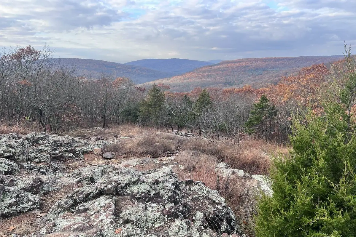
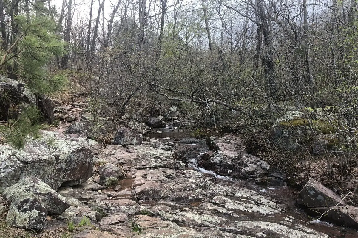
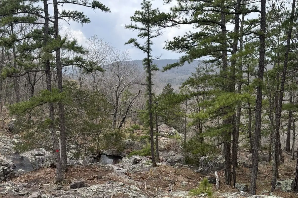
Taum Sauk Mountain sits inside Taum Sauk Mountain State Park, part of the St. Francois Mountains. Hikers love the Mina Sauk Falls trail, which leads to Missouri’s highest waterfall.
You’ll find plenty of outdoor activities and lots of photo ops. Whether you want a quick stop or a day hike, this mountain puts Missouri’s rugged side front and center.
Location And Access
Taum Sauk Mountain rises in the St. Francois Mountains of southeastern Missouri. The GPS coordinates are 37.5668°N, -90.7386°W.
It’s the highest natural point in the state. You can get there by driving to Taum Sauk Mountain State Park, about 50 miles southwest of St. Louis.
Missouri Route 21 and Highway 67 will take you there. Once you’re in the park, you’ll spot marked trails leading up.
The Taum Sauk Trail is the most popular—it’s about 3 miles long. The hike’s moderately tough, so bring good shoes and water.
Parking sits near the trailhead, with basic facilities like restrooms nearby. Just pop the coordinates or park name into your map app and you’re set.
Check park hours and the weather before you head out. A little planning goes a long way.
Directions: How To Get There And What To Expect
To reach Taum Sauk Mountain, head for Taum Sauk Mountain State Park using GPS coordinates 37.5667, -90.7386. Plug these into your phone or car GPS for a smooth trip.
If you’re starting in St. Louis, drive south on Interstate 55, then take Highway 67 south toward Farmington. From Farmington, follow Highway 21 south to the park entrance.
Parking’s available at the main lot by the visitor center. There’s a small entry fee for the state park.
You’ll find well-marked hiking trails to the summit. The main trail is about 3 miles round trip and moderately challenging.
Wear sturdy shoes and bring water. Weather can turn fast, so dress in layers.
The view from the top is worth it—on a clear day, you’ll see forests and hills for miles. Facilities are pretty basic, with restrooms by the parking area but not along the trail.
What to Bring:
- Water
- Snacks
- Hiking shoes
- Weather-appropriate clothing
- Phone with GPS
Plan for 2-3 hours if you want to hike and soak up the views.
Amenities And Activities
Taum Sauk Mountain has basic amenities like parking and picnic areas. Restrooms are near the visitor center, but they can get crowded during busy times.
Bring your own water and snacks—it’s just easier. Hiking’s the main draw here, with trails ranging from easy to a bit tough.
The Taum Sauk Trail offers great scenery and a shot at spotting native plants and wildlife. If fishing’s your thing, Johnson’s Shut-Ins State Park nearby has streams for casting a line.
Birdwatchers will find plenty to see, too. The terrain gets rugged, so stick to marked trails.
Here’s a quick look at what you’ll find:
| Amenity | Description |
|---|---|
| Parking | Available near trailheads |
| Restrooms | Near visitor center |
| Picnic Areas | Open spaces with tables |
| Hiking Trails | Varied lengths and difficulty |
| Fishing | Available nearby in streams |
Maps and info boards help guide your visit. Sometimes rangers or staff are around, but it’s smart to check hours first.
Camping Regulations And Restrictions
Camping near Taum Sauk Mountain comes with a few rules. You’ve got to stick to designated areas—it’s about protecting the land and keeping folks safe.
Use only established campsites with proper facilities. Setting up elsewhere isn’t allowed.
Fires go in designated rings or grills only. Always keep water or a fire extinguisher handy—wildfires are no joke.
Pets? Keep them on a leash that’s 6 feet or shorter, and always clean up after them.
You’ll need a camping permit for overnight stays. Get one online or at the park office before you set up.
Keep noise down, especially at night. It makes the experience better for everyone.
Follow these rules, and you’ll help keep the area safe and enjoyable. Nobody wants a fine or to be asked to leave.
Leave No Trace
When you visit Taum Sauk Mountain, try to follow the Leave No Trace principles. These help keep the natural area healthy for everyone.
Carry out everything you bring in—trash, food, gear, all of it. Even little things like wrappers or cigarette butts make a difference.
Stick to marked trails so you don’t trample plants or erode the soil. If you see wildlife, watch from a distance and let them be.
Need a bathroom break? Go at least 200 feet from water sources. Pack out your used toilet paper or use natural stuff that breaks down fast.
Only camp in established areas if camping is allowed. Use a stove instead of a fire whenever you can. If you do build a fire, keep it small and make sure it’s out before you leave.
Your choices help keep Taum Sauk Mountain wild and beautiful. It really does matter.
Resource Information Sources
Bureau of Land Management
Missouri Climate Data – U.S. Climate Data
Recreation.Gov
Camping in Missouri – New Missouri State Parks
Taum Sauk Mountain Free Boondocking Locations

Little Scotia Campground
37.529007, -91.330353
Located in the heart of the Ozarks, Little Scotia Campground offers a serene camping experience with easy access to local hiking and outdoor activities. Nestled in a beautiful forested area, this campground provides a peaceful retreat for visitors looking to escape into nature. The campground is situated near the Big River, making it an ideal location for water-based activities such as fishing and kayaking.
Things to Do: Fishing enthusiasts will appreciate the Big River’s abundance of bass, catfish, and bluegill. The campground is also a prime spot for hiking, with several trails that offer scenic views of the surrounding forest. Birdwatching is popular in the area, as the region is home to a variety of species. During the warmer months, visitors can enjoy swimming and relaxing by the river.
Directions: From the town of Irondale, head east on Highway 21 for about 5 miles. Turn left onto County Road 300 and follow the signs to the campground.
Vehicle Access: Little Scotia Campground is suitable for tents and small RVs or trailers. The campground offers picnic tables, fire rings, and vault toilets. There are no hookups available, so campers should prepare for a primitive camping experience.

Indian Trail CA Boondocking
37.693193, -91.340377
Indian Trail Conservation Area, located in Crawford County, Missouri, offers a peaceful and secluded boondocking experience for campers who love the outdoors. The area is surrounded by dense forests and rolling hills, making it perfect for those looking to disconnect from modern life and immerse themselves in nature.
Things to Do: The conservation area features a network of trails ideal for hiking and wildlife viewing. The region is rich in biodiversity, making it a prime location for birdwatching and spotting local wildlife such as deer and wild turkey. The area is also perfect for fishing, with several nearby streams and ponds. Camping here provides a quiet environment to enjoy the beauty of the Ozarks, far from the noise of more crowded locations.
Directions: From Highway 44, take exit 225 for Highway 49. Continue for about 8 miles before turning left onto Indian Trail Road. Follow the gravel road to the conservation area.
Vehicle Access: This boondocking location is accessible to tents, small RVs, and trailers. There are no amenities or hookups at the site, so visitors must be fully self-sufficient. Vault toilets are available, but campers should bring their own water and supplies.

Lindsey Mt TH Boondocking
37.628332, -90.830794
Located in the beautiful Mark Twain National Forest, Lindsey Mt TH Boondocking offers a quiet and remote camping experience for those seeking solitude in the woods. The area is known for its hiking trails and stunning natural scenery, making it a great destination for outdoor enthusiasts.
Things to Do: The Lindsey Mountain Trailhead offers access to several miles of hiking trails through dense forest, with scenic views and peaceful surroundings. Hikers can explore the region’s natural beauty, including rock formations, streams, and abundant wildlife. Fishing is available in nearby rivers, and wildlife viewing is another popular activity. The area is great for those looking to enjoy a peaceful camping experience away from the crowds.
Directions: From the town of Viburnum, take Highway 21 south for approximately 6 miles. Turn left onto Forest Road 2310 and follow the signs to the Lindsey Mountain Trailhead.
Vehicle Access: This boondocking site is suitable for tents and small RVs. There are no hookups or amenities at the site, so campers should be prepared for a primitive experience. Vault toilets are available, but campers should bring water and other necessities.

Hazel Creek CG
37.838001, -91.016998
Hazel Creek Campground, located in the Ozarks near the Big Piney River, offers a peaceful and scenic retreat for nature lovers. This campground is perfect for those who want to explore the local wilderness, with access to hiking, fishing, and wildlife watching. The serene environment makes it an excellent spot for camping and relaxation.
Things to Do: Hazel Creek is known for its fishing opportunities, with the Big Piney River offering a range of species, including bass and catfish. The area is also ideal for hiking, with trails that lead to stunning views of the river and surrounding hills. Wildlife is abundant, and birdwatching is popular in the area. Visitors can also enjoy a peaceful picnic by the river or simply relax and enjoy the natural beauty.
Directions: From Highway 63, take the exit for County Road 420. Continue on the gravel road for 3 miles, following signs to the campground.
Vehicle Access: Hazel Creek CG is suitable for both tents and small RVs. The campground offers primitive camping sites with picnic tables, fire rings, and vault toilets. There are no hookups available, so visitors should be fully prepared for a self-sufficient camping experience.

Bismarck Conservation Area
37.732291, -90.638269
Bismarck Conservation Area, located in St. Francois County, Missouri, offers a peaceful and scenic escape for outdoor enthusiasts. The area is primarily known for its well-maintained hiking trails, diverse wildlife, and peaceful atmosphere, making it an excellent spot for birdwatching, fishing, and hiking. Surrounded by lush forests and rolling hills, it offers a great mix of recreational opportunities and nature exploration.
Things to Do: Hiking is a popular activity here, with trails ranging in difficulty and offering views of the forest and local wildlife. The conservation area is also a prime spot for birdwatching, with numerous species inhabiting the area throughout the year. Fishing is allowed in several of the area’s ponds, and visitors can fish for bass, bluegill, and catfish. In the warmer months, the area is perfect for picnicking and enjoying the natural surroundings.
Directions: From the town of Bismarck, take Highway 32 east for approximately 2 miles. Turn left onto County Road 100 and follow signs to the conservation area. The roads are paved and easily accessible.
Vehicle Access: The conservation area offers parking for visitors, though the campsites are primitive with no hookups. It is suitable for tents and small RVs. Facilities include picnic tables, fire rings, and vault toilets. Be prepared for primitive camping with no electricity or water hookups.

Bootleg Access
37.81343, -90.77207
Bootleg Access is located along the St. Francois River in southeast Missouri, offering a serene and remote camping experience for those who enjoy getting away from it all. This primitive camping area provides a quiet location for fishing, kayaking, and enjoying the natural beauty of the river valley. Its close proximity to the river makes it an ideal spot for water-based activities and outdoor recreation.
Things to Do: Fishing is a main attraction at Bootleg Access, with plenty of opportunities to catch bass, catfish, and sunfish. The river’s calm waters are perfect for kayaking or canoeing, and visitors can also enjoy swimming during warmer months. The surrounding forest offers hiking opportunities, with scenic views and wildlife sightings. Since this is a more remote area, visitors can enjoy a peaceful environment without the hustle and bustle of crowded campgrounds.
Directions: From Highway 21, head east on County Road 208 for approximately 4 miles, then turn right onto Bootleg Road and follow signs leading to the access area. The road is gravel and easily navigable by most vehicles.
Vehicle Access: Bootleg Access is best suited for tents, small trailers, and RVs. The camping area is primitive, with no hookups, and visitors are advised to pack in and pack out all supplies. Vault toilets and picnic tables are provided, but drinking water is not available on-site.

Berryman Trail Campground
37.931, -91.061997
Located in the Mark Twain National Forest, Berryman Trail Campground is a popular destination for hikers and outdoor enthusiasts. It is well-known for its access to the Berryman Trail, a scenic trail system that offers a variety of hiking and backpacking experiences. This campground is perfect for visitors who enjoy long hikes, nature walks, and peaceful surroundings.
Things to Do: The Berryman Trail, which spans 24 miles, is the main attraction for visitors, offering an excellent trail for hiking and backpacking. The trail passes through diverse landscapes, including forests, streams, and rugged terrain, providing a challenging yet rewarding experience for hikers. Fishing is available in nearby streams, and the area is known for its excellent birdwatching opportunities. Camping in the area allows visitors to take advantage of the tranquil setting and enjoy starry nights in a serene environment.
Directions: From the town of Potosi, Missouri, head north on Highway 21 for about 10 miles, then turn left onto Berryman Trail Road. The campground is well-marked and accessible by paved and gravel roads.
Vehicle Access: The campground is suitable for tents and small RVs or trailers. It offers a range of sites, some of which are equipped with picnic tables, fire rings, and vault toilets. There are no hookups, so campers should come prepared for a primitive experience. The area is popular among hikers, so those looking for a quiet and remote camping experience will appreciate the solitude and beautiful surroundings.
Taum Sauk Mountain Paid Campgrounds

Loggers Lake Campground
37.388228, -91.260454
Loggers Lake Campground is located within the Mark Twain National Forest in southeastern Missouri. Centered around a small, clear lake, this campground offers a quiet and scenic setting perfect for visitors looking to enjoy nature in a relatively undeveloped area. Surrounded by forested hills, Loggers Lake is a popular destination for fishing, swimming, and relaxing away from busy tourist spots.
Things to Do: Fishing is a key activity, with the lake stocked with bass, catfish, and bluegill. Swimming and non-motorized boating are allowed, making the lake a good spot for families with canoes or kayaks. Hiking trails around the lake provide opportunities for nature walks and wildlife observation. The forest also offers seasonal hunting nearby. Campers can enjoy stargazing on clear nights due to low light pollution.
Directions: From Bunker, Missouri, take Highway 72 east for approximately 1 mile. Turn south on County Road 561 and follow signs leading to Loggers Lake. Access roads are gravel but typically maintained.
Vehicle Access: Best suited for tents, vans, small RVs, and trailers. No hookups are available. Campsites include picnic tables, fire rings, and access to vault toilets. Drinking water is available seasonally. Campers should be prepared for primitive camping conditions and pack out all trash.
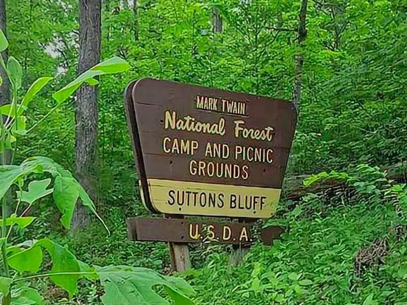
Sutton Bluff Campground
Sutton Bluff Campground is situated along the West Fork Black River in the Mark Twain National Forest. This scenic campground offers shaded sites under large trees with river access, making it popular with anglers, kayakers, and off-highway vehicle (OHV) enthusiasts. It also serves as a staging area for the Sutton Bluff OHV Trail System.
Things to Do: Fishing in the West Fork Black River is excellent for smallmouth bass and sunfish. Swimming holes are available along the river. The Sutton Bluff OHV Trail System provides over 20 miles of trails open to ATVs, dirt bikes, and other off-road vehicles. Hiking and wildlife observation are also popular, with the forest supporting a range of bird species and native wildlife.
Directions: From Centerville, Missouri, head north on Highway 21 for 4 miles. Turn east onto County Road 915 and follow signage for Sutton Bluff Campground. The road is gravel but generally passable by all vehicles.
Vehicle Access: Suitable for tents, vans, trailers, and mid-sized RVs. Larger RVs may find maneuvering some campsites challenging. Amenities include picnic tables, fire rings, vault toilets, and drinking water during the season. No electric or sewer hookups are available. Quiet hours are enforced, especially near family camping areas.
Sutton Bluff Campground
37.475586, -91.006592

Red Bluff Campground
37.816391, -91.16639
Red Bluff Campground lies along the Huzzah Creek in southeastern Missouri’s Mark Twain National Forest. Known for its striking red rock bluffs overlooking the creek, this campground is a favorite among those seeking a quiet retreat with easy access to water activities and hiking trails.
Things to Do: Huzzah Creek is ideal for wading, fishing, and floating. Canoeing and kayaking are popular during higher water levels. The area surrounding Red Bluff offers scenic hiking opportunities and excellent birdwatching. Anglers can fish for smallmouth bass and panfish in the creek. During summer months, swimming and picnicking along the water’s edge are common.
Directions: From Davisville, Missouri, head north on Highway V for about 3 miles. Turn east onto County Road 565 and follow it to Red Bluff Campground. Roads are a mix of pavement and gravel, generally accessible for most vehicles.
Vehicle Access: Accessible for tents, vans, and smaller RVs and trailers. Larger rigs may find the narrow access roads challenging. Campsites offer picnic tables, fire rings, and vault toilets. No hookups are available, and drinking water is seasonal. This is a quiet campground ideal for those preferring rustic, riverside camping with beautiful bluff views.
Taum Sauk Mountain Paid Campgrounds
Frequently Asked Questions
Taum Sauk Mountain stands as Missouri’s highest point and offers a bunch of outdoor activities. You can hike, visit waterfalls, and check out historical spots. Weather changes with the season, and camping’s available nearby.
What is the significance of Taum Sauk Mountain’s height in comparison to other peaks in Missouri?
Taum Sauk Mountain tops out at 1,772 feet, making it the highest spot in Missouri. You’ll get unique views and cooler air compared to the rest of the state.
What are the main recreational activities available at Taum Sauk Mountain State Park?
Hiking’s the big one, especially the Mina Sauk Falls Trail. You can also birdwatch, picnic, snap photos, and dig into nature study.
How do I access the Mina Sauk Falls Trail and what should I expect during the hike?
You’ll find the trailhead inside Taum Sauk Mountain State Park, off Highway 21. The hike’s about 3 miles round trip and takes some effort, but you’ll see Missouri’s highest waterfall at the end.
What are the historical points of interest near Taum Sauk Mountain?
There are old mining sites and remains of early settlements nearby. You’ll also find info about the area’s indigenous history. These places give you a feel for local culture and the land’s past.
What is the best time of year to visit Taum Sauk Mountain for optimal weather conditions?
Late spring through early fall usually has the best weather—mild temps and less rain. Winter can be icy and cold, making hiking tricky. Fall colors are a big draw, too.
Are there any camping facilities or accommodations available in the vicinity of Taum Sauk Mountain?
The state park has campgrounds with some basic amenities. If you’re looking for something a bit more comfortable, nearby towns offer cabins and lodges too.
It’s a good idea to make reservations, especially when things get busy during peak seasons.